Learn how to get a permit to hike in the 35,000-acre Pequannock Watershed.
What is the Pequannock Watershed?
The Pequannock (Newark) Watershed consists of 35,000 acres of natural waterways, mountains, ponds, and streams as well as reservoirs used for fishing, hiking, horseback riding, hunting, and boating. The natural resource was purchased by the City of Newark in 1900 and is located in portions of 6 municipalities in Morris, Passaic, and Sussex Counties.
Who can hike in the Pequannock Watershed?
Hiking and parking in the Watershed requires paying a fee a valid hiking permit. You must carry the permit with you and place the decal on your car.
Why would I want a Watershed permit?
Hikers with a permit can access Bearfort Mountain and fire tower, Buckabear Mountain and Pond, Highlands Trail, and other trails.
Hikes
How do I get a permit?
You can buy a permit online, but you’ll have to pick it up in person. The hiking permit fee is $8 for Newark residents and $14 from non-Newark residents.
- Purchase a permit either online on the City of Newark website or at the Newark Division of Watershed Development office
- Pick up your permit and car parking decal at the Newark Division of Watershed Development office in West Milford:
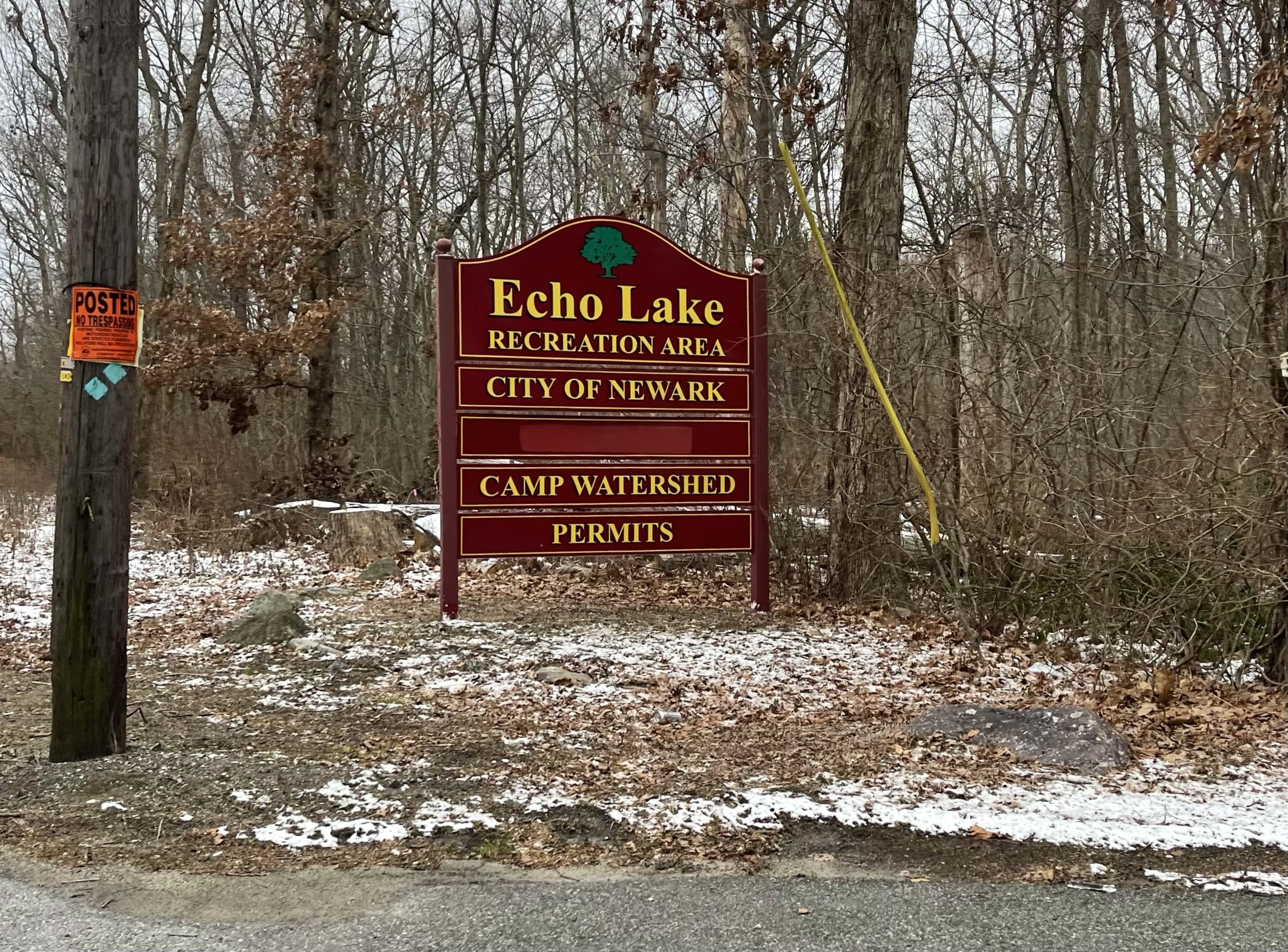
223 Echo Lake Road
West Milford, NJ 07840
Phone: (973) 697-1724
Hours: Monday - Friday, 8:00am - 3:45pm
From March to October: Sat: 8:00am - 1:00pm
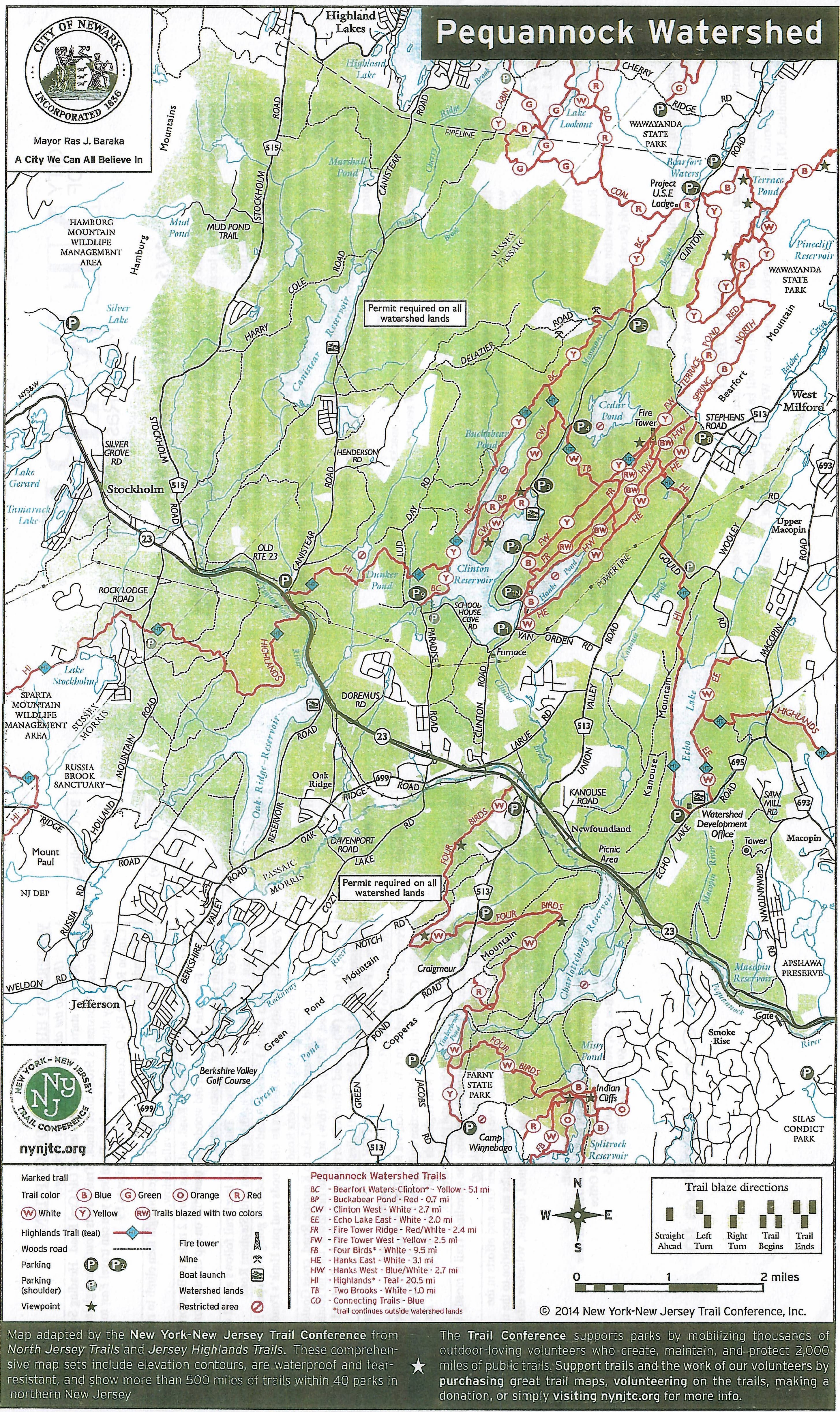
Pequannock Watershed Map
An 11″x18″ printed map (scan below) is available from the Newark Watershed office in West Milford.
Portions of the Pequannock Watershed are also included in the North Jersey Trails and Jersey Highlands Trails maps produced by the NY-NJ Trail Conference.
Season
| Jan 1 – Apr 22 | Hiking is permitted on all approved Watershed hiking Trails on all days. |
| Apr 23 – May 25 | Hiking is permitted on all approved Watershed riding Trails after 1:00pm on all weekdays and Saturdays so as to avoid conflict with the Wild Turkey Hunting Season. |
| May 26 – Sep 30 | Hiking is permitted on all approved Watershed hiking Trails on all days. |
| Oct 1 – Dec 31 | Hiking is permitted on all approved Watershed Hiking Trails on Sundays, so as to avoid conflict with hunters. |
| Year-round | Hiking is permitted in the Echo Lake Conservation area bounded by Echo Lake Road, Kanouse, Gould, Macopin and Route 23 on all days and the Hank Pond Conservation area bounded by Van Order, Clinton, Union Valley and Stephens Roads (except for Cedar Pond and its northern bog). |
Parking
Vehicle parking is permitted only in Watershed designated parking areas and at the head of most trails. If these areas are full, please park on the road shoulder, well off of the road.
Why does Newark own land in 6 other municipalities?
At the turn of the century, residents in the City of Newark were falling ill and dying from drinking bacteria infested water from the polluted Passaic River. Finding clean water to the northwest, the City of Newark locked up acres and acres of land there, 35,000 to be exact, taking much of the territory by eminent domain, and establishing the Newark Watershed. In the process, it protected and preserved deep forests, brooks, ponds and unspoiled landscapes surrounding the water’s source.
Hiking Trail Descriptions
BWC (Yellow): Major N-S trail starts at 0.4 miles as a left off Coal Road. Heading South trail crosses Mossman’s Brook three times. Trail travels South through laurel patch and grassy slopes to old pipe line. From here you can turn around or travel East to ClintonRoad at P4.
FTW (Yellow): Starts at P2 and is a 1.9 mile trail with rock ridges on right then climb to ridge with good view of Cedar Pond and the valley below.
FTR (Red/White): Starts 0.4 north of P1 off Clinton Road and runs North 2 miles to Bearfort Fire Tower. First mile follows an old woods road then runs on top of interesting rock range with open views of mountain slopes.
HW (Blue/White): Starts on west side of Hanks Pond. This mostly level trail follows an old woods road past Hank Pond 2.5 miles north to junction with Stephens Road.
HT (Teal/Diamond): From Macopin Road, go around Echo Lake to Kanouse Road, cross Gould Road, Union Valley Road, HE(w). HW (BW) and up to Fire Tower, then go south on FTW (Y) to CW (W) around Clinton Resrvoir, west to Dunker Pond and out to Canistear Road at Route 23 (about 20 miles).
TB (White): Starts at P4, travels East to West to meet with FTW trail. Trail crosses several small ridges and two brooks (Cedar and Clinton), both on lodge bridges.
CW (White): From P9, 1.6 miles North to junction with BWC. Perfect for family walks with nice views of reservoir and Clinton point, originally built by the CCC in the 1930s.
ELE (White): Starts near Echo Lake boat Launch and hugs the shoreline. Trail is mostly leveled, 2.8 miles.
Rules & Regulations
- Each person who wishes to hike on the Newark’s Watershed property must obtain a valid hiking permit.
- Hiking is restricted to those marked trails indicated on the New York-New Jersey Trail Conference map provided in this brochure.
- Hikers must carry their permit while hiking and should conspicuously display the decal on the vehicle inside left rear window in the lower right hand corner.
- Hiking is prohibited on or through those areas posted or designated as restricted.
- Related uses such as photography, bird-watching and cross country skiing permitted under this permit.
- The photographing of dams or power lines is prohibited.
- No fires, swimming, littering, unleashed pets, sunbathing, picnicking, all-terrain vehicles or camping is permitted on Watershed property.
- Hiking is permitted from sunrise to sunset.
- Hikers, be prepared. Carry a map, cellular telephone, water, snacks and a flashlight. Let someone know where you are and your expected time of return.


