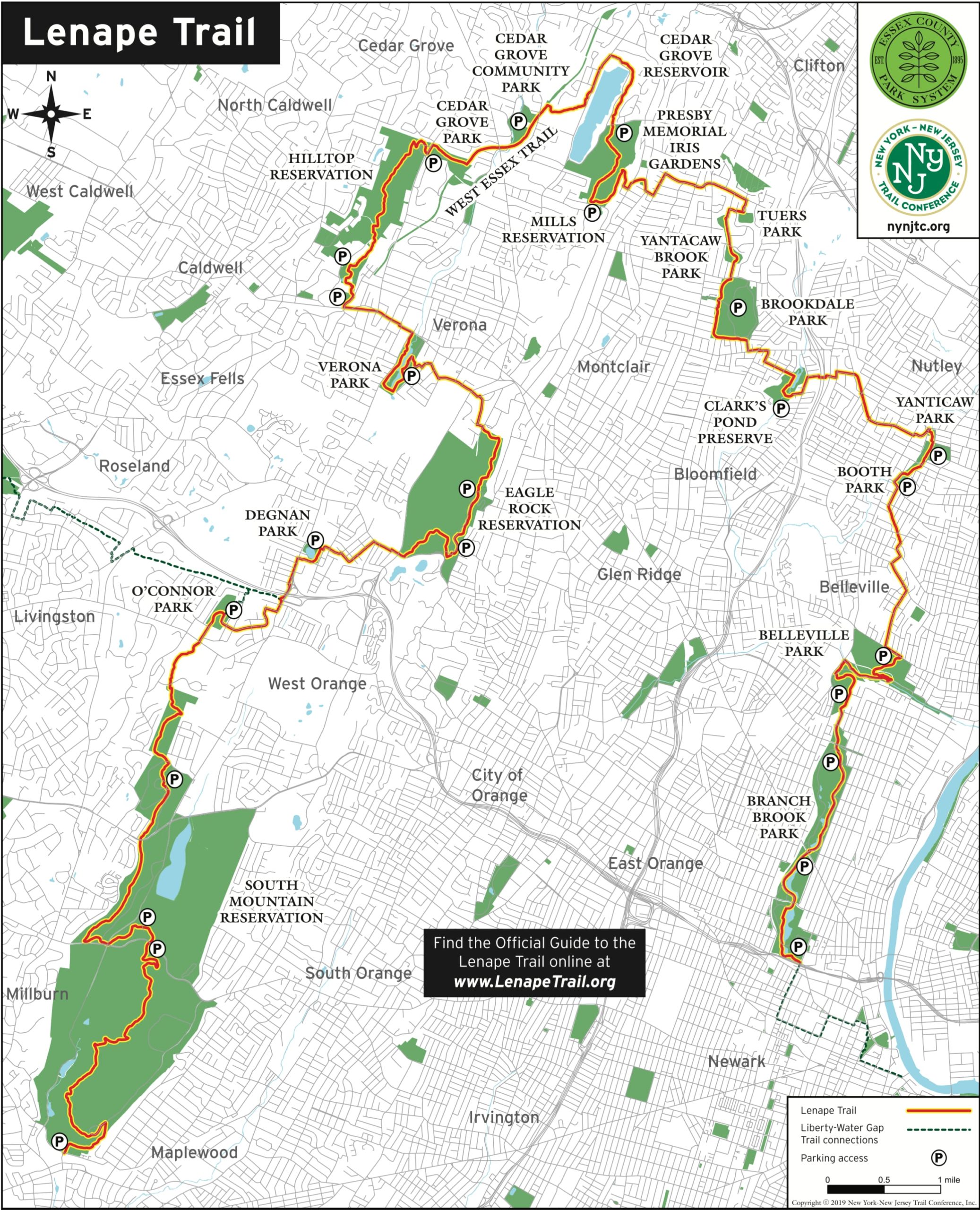
Overview: The Lenape Trail is a unique, 36-mile urban/suburban trail connecting 18 parks in 11 municipalities in Essex County named in recognition of the Lenape people, the original inhabitants of the area. It is the only urban trail in New Jersey maintained by the NY-NJ Trail Conference. About 70% of the trail goes through parks and woodlands while 30% follows streets.
An excellent 45-page guide to the trail was created by the NY-NJ Trail Conference. This web page borrows heavily from the guide.

Length: 36 miles
Location: 11 municipalities in Essex County, New Jersey
Parking: The parking areas nearest the two endpoints of the trail are:
- South Mountain Reservation Locust Grove parking lot (map)
- Branch Brook Park Roller Skating Center (map)
For an end-to-end hike, the easiest approach is to leave a car at one end and have someone drop you off at the other.
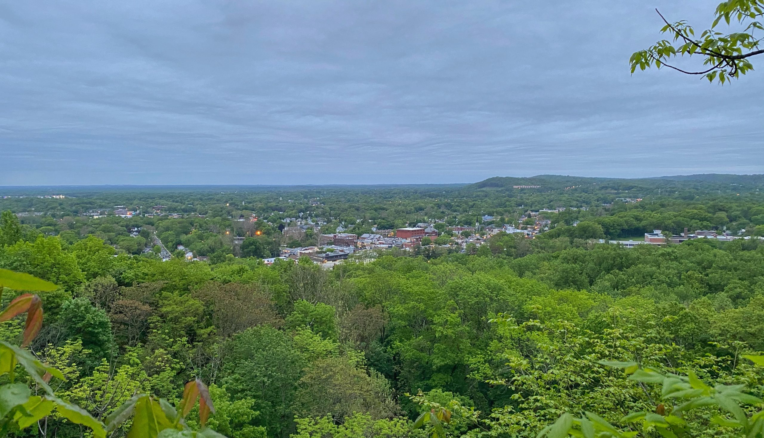
My opinion: The Lenape Trail passes through and connects some beautiful parks and woodlands, but it requires a considerable amount of road walking and therefore does not offer a high reward/effort ratio as an end-to-end hike. Walking the entire trail in one day is hard and will probably take 12 to 16 hours or more (I did it in 12.5 hours). If you calibrate your expectations accordingly, it’s a good personal challenge and unique way to see many towns and areas of Essex County.
Maps:
- Digital Maps
- PDF Maps
- Lenape Trail Overview Map
- Lenape Trail Map 1 of 7 – Branch Brook to Belleville
- Lenape Trail Map 2 of 7 – Belleville to Brookdale
- Lenape Trail Map 3 of 7 – Brookdale to West Essex Trail
- Lenape Trail Map 4 of 7 – West Essex Trail to Eagle Rock
- Lenape Trail Map 5 of 7 – Eagle Rock to O’Connor
- Lenape Trail Map 6 of 7 – South Mountain (North)
- Lenape Trail Map 7 of 7 – South Mountain (South)
Resources:
- NY-NJ Trail Conference Lenape Trail website
- NY-NJ Trail Conference Lenape Trail Guide website
- Official Lenape Trail Guide (pdf)
- Lenape Trail History + Overview Webinar – by Trail Chair Dave DeShazer and Lenape Trail Guide author Debra Kagan
Lenape Trail History
Work on the Lenape Trail began in 1976, spearheaded by Al Kent, a former Trail Coordinator for the Morris County Parks Department. Al wanted the public to experience as many natural resources and points of interest in Essex County as possible, and he strove to connect them through a trail that traversed towns, parks, woodlands, residential areas, and cities along the way. Al completed the blazing of the trail in its original form in 1979. Al was a truly remarkable individual who, even into his mid-80s, performed maintenance nearly every day throughout the year on both the Lenape Trail and Patriots’ Path in Morris County. Mr. Kent was long active with the Sierra Club and the New Jersey Environmental Lobby and was a life member of the New York-New Jersey Trail Conference. Al passed away on September 17, 2018, and is greatly missed by the trail community.
The year 2010 saw a resurgence of interest in the Lenape Trail. Volunteer trail leader Steve Marano worked with Ed Goodell, Executive Director of the New York-New Jersey Trail Conference at the time, to involve the Trail Conference in management and maintenance of the trail. This revitalization project saw the entire trail re-blazed, marked in strategic locations with professionally-printed medallions, and planned for the installation of navigational posts along the trail. This was also the year that Essex County issued a formal Letter of Adoption for the trail, accompanied by a press conference from County Executive Joe DiVincenzo.
In 2017, The Partners for Health Foundation provided an award to bolster this effort and offer increased trail planning, public workshops, and volunteer support for the trail – resulting in the first formal Trail Conference maps of the trail, including an interactive digital map. An additional award in 2018 from Partners for Health made the Official Lenape Trail Guide, and the trail continues to improve with each passing year.
About the Lenape People
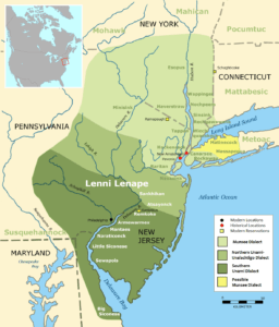
languages spoken in the New
York-New Jersey area. Credit: Wikipedia
The name of the Lenape Trail is intended to pay respect to the Lenape (English: Len-nah-pay) people, who lived on the lands around Essex County long before European settlers arrived and displaced them. They are also sometimes called the Leni Lenape or Delaware Indians, because of their communities in the Delaware River Basin. While the Lenape Trail was not laid out to follow specific routes used by the Lenape, it does pass through lands that are historically theirs. Far beyond Essex County, the Lenape people’s historical territory includes present-day New Jersey and eastern Pennsylvania along the Delaware River watershed, New York City, western Long Island, and the Lower Hudson Valley. This area was referred to as “Lenapehoking” by the Lenape.
Starting with the so-called purchase of Manhattan in 1626, the Lenape and other native communities in the New York–New Jersey area were forced or coaxed into signing a series of massive land agreements, many with conflicting boundaries and fraudulent residual rights for hunting and other use. The Walking Purchase of 1737 alone claimed 1,200,000 acres of Lenape land in Pennsylvania along the Delaware including where the Appalachian Trail now crosses. Their lands taken from them, the Lenape were largely forced to move to Ohio, Canada, Wisconsin, Oklahoma and other areas. The French-Indian War, the American Revolution, inter-tribal warfare with the Iroquois, and the scourge of smallpox also decimated many tribal communities.
Today, Lenape people belong to the Delaware Nation and Delaware Tribe of Indians in Oklahoma; the Stockbridge-Munsee Community in Wisconsin; and the Munsee-Delaware Nation, Moravian of the Thames First Nation, and Delaware of Six Nations in Ontario. The name “Delaware” comes from British military officer Thomas West, who carried the family title Lord De La Warr and was known for his brutal campaigns against the Irish and later against the Lenape and other tribes. West served as a governor and military leader in Virginia in the early 1600s.
Although the Lenape were forced from their homes, time has not erased the proof of their presence all through the New York–New Jersey region. Their words remain embedded in our geography, including examples such as Manhattan (or Mana-hatta), Hackensack, Allamuchy, Kittatinny, Lake Hopatcong, HoHo-Kus, Cupsaw Lake, Ramapo, Cheesequake, and many more. While most were forced into displacement, some Lenape descendants remained in New York and New Jersey. This includes members of the Ramapough Lenape, who often intermarried with other communities and are working to hold on to as much of their heritage as possible in spite of ongoing assaults on their lands, language and culture. To this day the Ramapough and other Lenape communities in the United States and Canada continue to explore their history and find ways to celebrate and protect their culture.
Trail description
The full trail could be done by starting at either end. Below are some highlights along the trail beginning from the Locust Grove parking lot at South Mountain Reservation and ending at Branch Brook Park. Most descriptions are taken from the NY-NJ Trail Conference’s Official Guide to the Lenape Trail.
Mile 0 – Trailhead at the Locust Grove parking lot (Millburn)
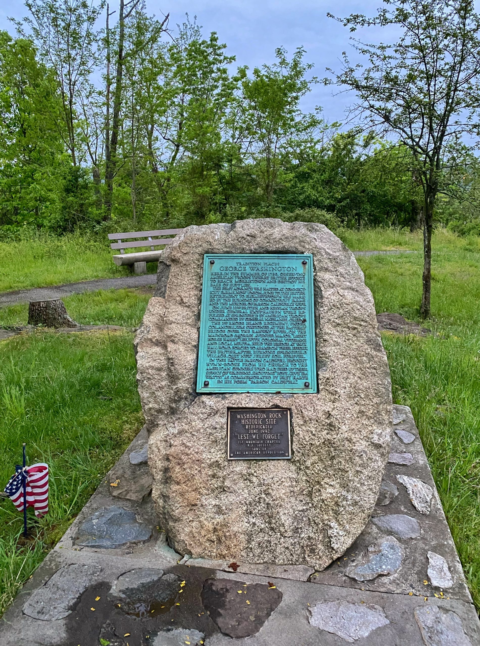
Mile 0.5 – Washington Rock, South Mountain Reservation
Local lore holds that General George Washington stood here in June of 1780 to oversee maneuvers of the Continental Army in the battles of Connecticut Farms and Springfield that occurred in the valley below. The Watchung Mountains were strategic to the Revolutionary War effort, particularly Hobart’s Gap, the break in the range observable from the overlook on this 500-foot cliff. In 1780, the British occupied Staten Island and New York City. Hobart’s Gap was one of the few places that the British Army might pass through to Morristown. In order to mobilize the militia in the event of an attack, General Washington created an alert system of 23 bonfire signal beacons along the mountain range. On June 23, an American lookout lit signal beacon No. 9 near this spot, and Essex County and Newark Militia were first warned that the British had launched an attack westward toward “the Gap.” After intense fighting, the British advance was repelled, and they would not make a major incursion into New Jersey again.
Mile 0.75 – Quarry Overlook, South Mountain Reservation
This overlook (just off the side of the trail) is at the top of a 139-foot-high cliff, created by the mining operations of trap rock quarry originally owned by Charles A. Lighthipe, a prominent 19th century citizen of Orange. The durable crushed rock was a key element for the development of new road infrastructure, critical to growing industry in the area. The quarry had a crusher that was housed in a building at the bottom of the cliffs, and after the stone was crushed it was loaded onto train cars. These cars were then pulled up along the bottom of the hill from the Morris and Essex line of the Delaware and Lackawanna Railroad. Concerned that the quarry would expand farther into the parkland, the Essex County Park Commission purchased the Lighthipe Quarry in 1913 and preserved the property from further development.
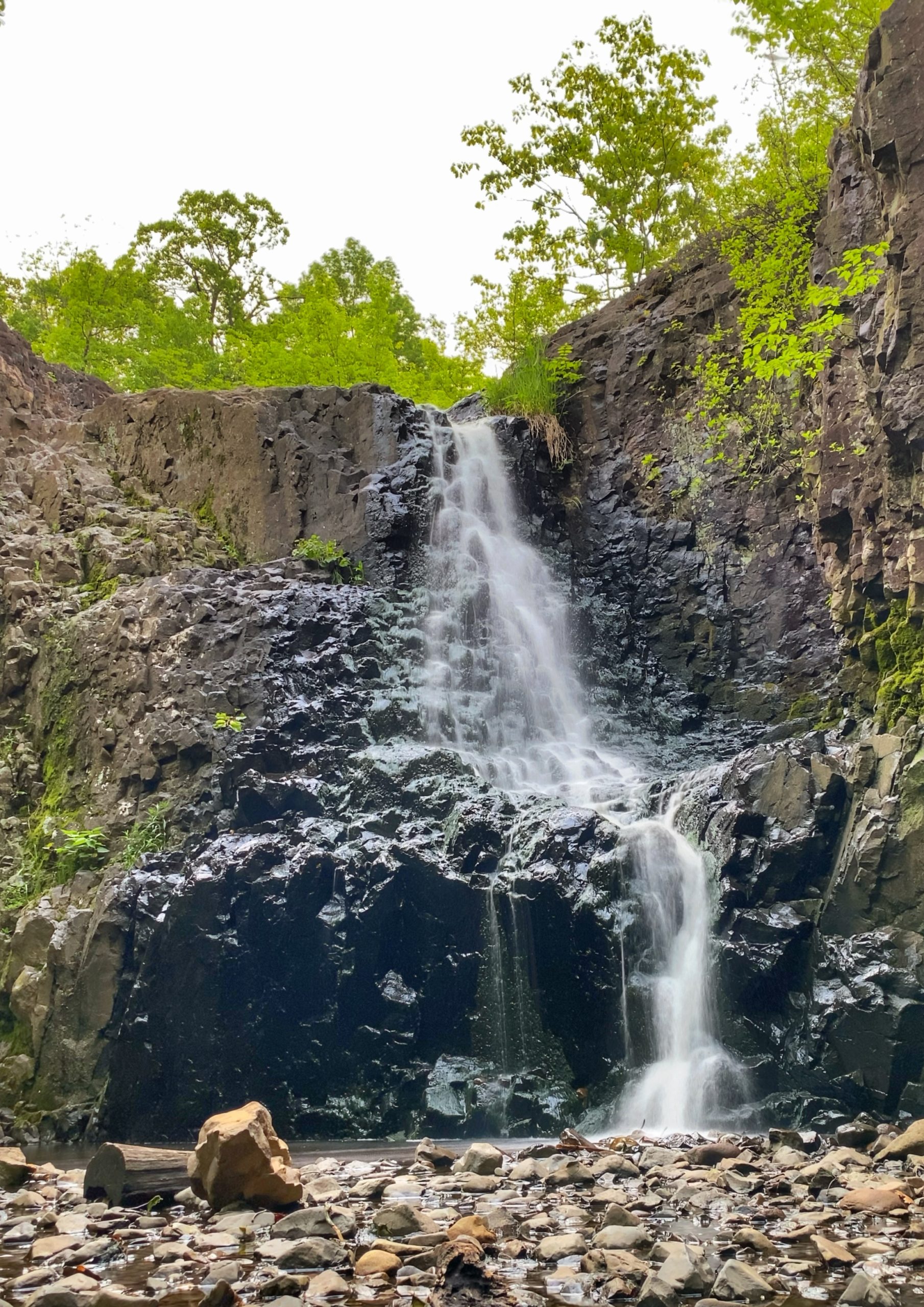
Mile 3 – Hemlock Falls, South Mountain Reservation
Hemlock Falls is a dramatic 25-foot-high waterfall on Hemlock Brook, a tributary of the Rahway River. You can view the falls cascading over boulders and ending in a small pond at its base. Hemlock Falls is an impressive sight shortly after heavy rains and offers scenic overlooks from a short distance along the reservation’s Hemlock Falls Loop Trail.
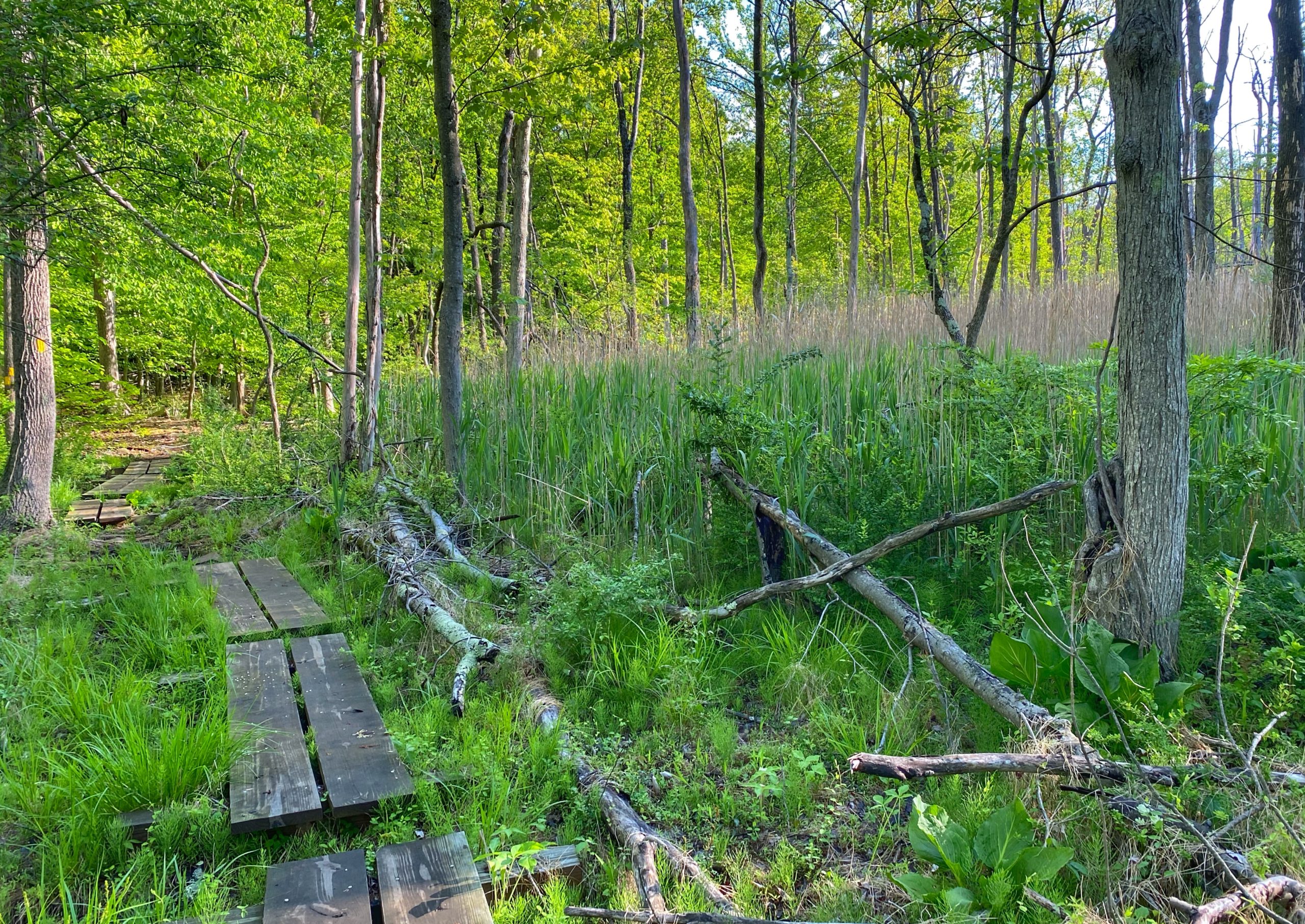
Mile 7 – South Mountain Connector Trail, South Mountain Reservation
The South Mountain Connector was probably my favorite part of the entire Lenape Trail.
The completion of the South Mountain Connector in 2017 resulted in the full route of the Lenape Trail as we know it today. This stretch of trail between Mount Pleasant Avenue and Whitbay Drive finally connected the South Mountain portion of the Lenape Trail to the rest of the route, giving the trail its distinctive “horseshoe” shape. The trail project was spearheaded and carried out by volunteers of the South Mountain Conservancy with support from the Trail Conference.
Mile 8.5 – O’Connor Park (West Orange)
Operated by the West Orange Recreation Department, O’Connor Park is located on Ralph Road at the intersection of Lorelei Road. O’Connor Park features a playground, three multi-purpose fields, four tennis courts with lights, two basketball courts, a street hockey court with lights, a walking path, and an ecosystem with a hands-on living science exhibit. The two-tiered ecosystem illustrates the interdependency of life forms and includes a wetlands area and a stream-fed pond.

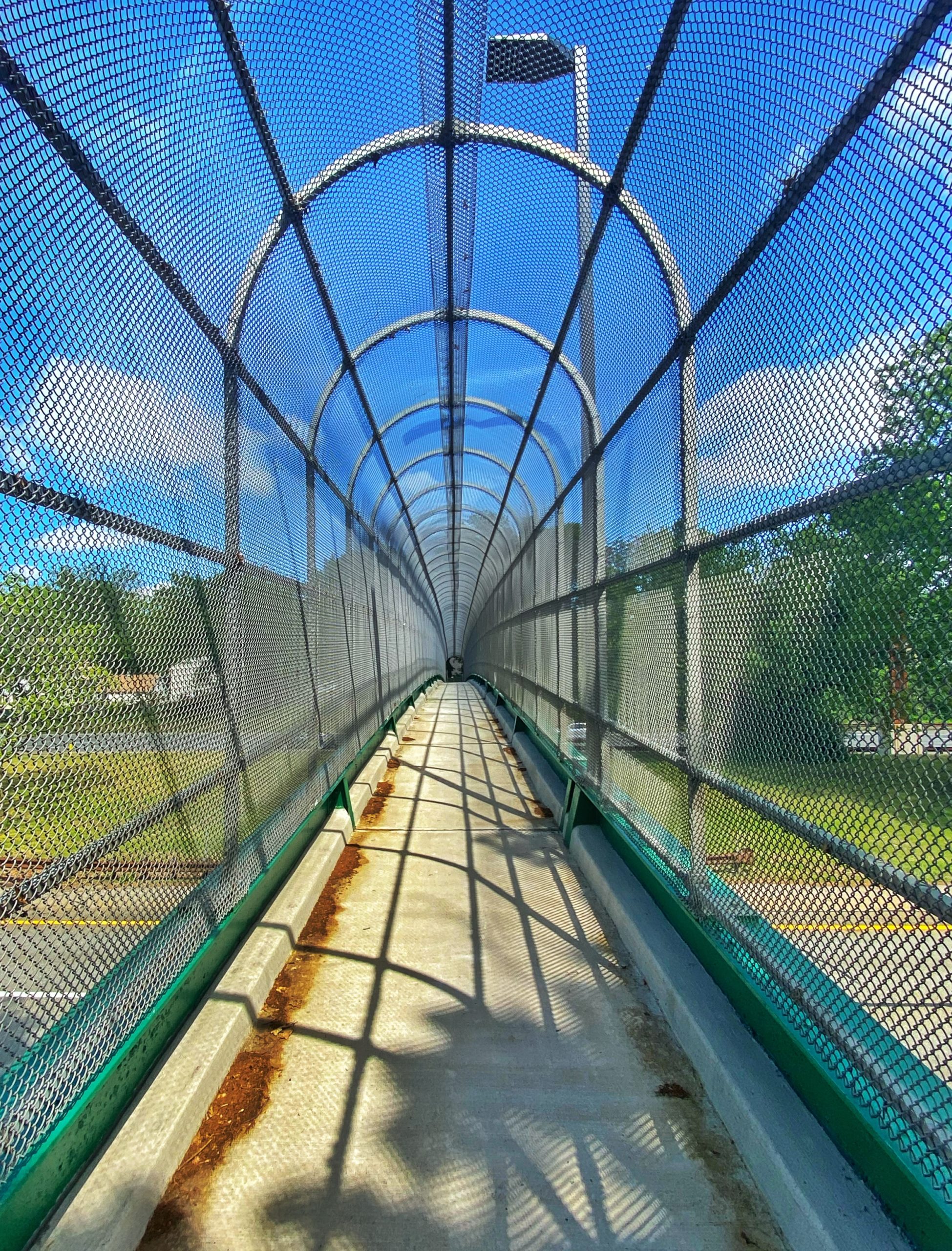
Mile 9.5 – I-280 Underpass
It is what it is. Beautiful in its own way.

Mile 10 – Degnan Park (West Orange)
Operated by the West Orange Recreation Department, Degnan Park is located at Pleasant Valley Way in West Orange. The park has a playground, five tennis courts with lights, a softball field with lights, and a basketball court. Vincent’s Pond is nestled in the heart of the park and features a fishing dock. The park was named in honor of Bernard M. Degnan, a longtime West Orange public servant who served as West Orange Mayor from 1938 to 1951.
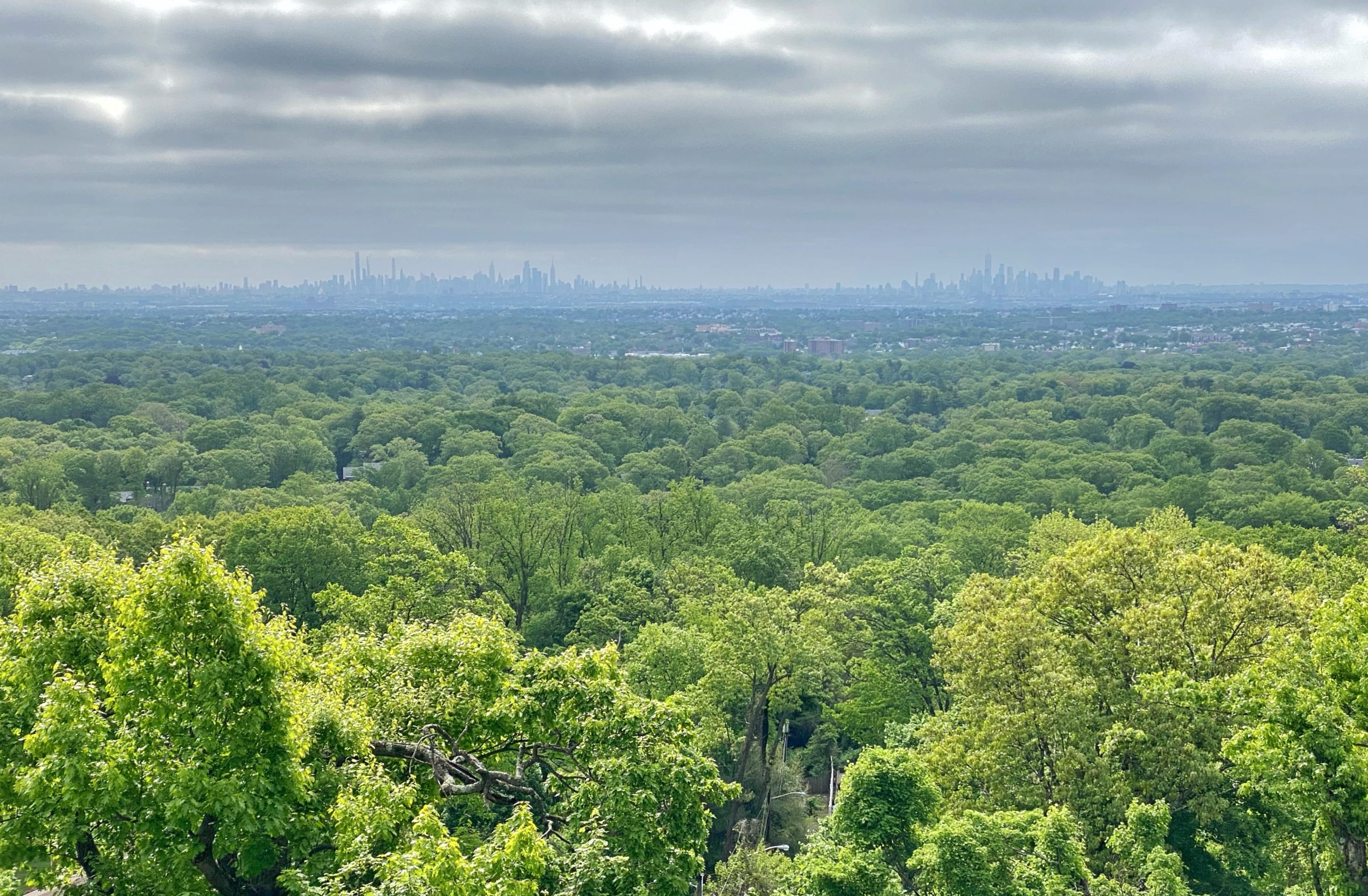
Mile 11.5 – Eagle Rock Overlook and September 11 Memorial, Eagle Rock Reservation
Eagle Rock Reservation, a 400-plus-acre reserve along the crest of the Watchung Mountains ridgeline, got its name in the early 19th century when bald eagles were said to nest in the rocky cliffs on its eastern edge. There are multiple hiking trails and bridle paths throughout the wooded forest, and a lookout point offers sweeping panoramas of New Jersey and the New York City skyline. From this vantage point, George Washington’s army monitored British troop movements across the Hudson River during the American Revolution, and more recently, horrified crowds gathered on September 11, 2001.
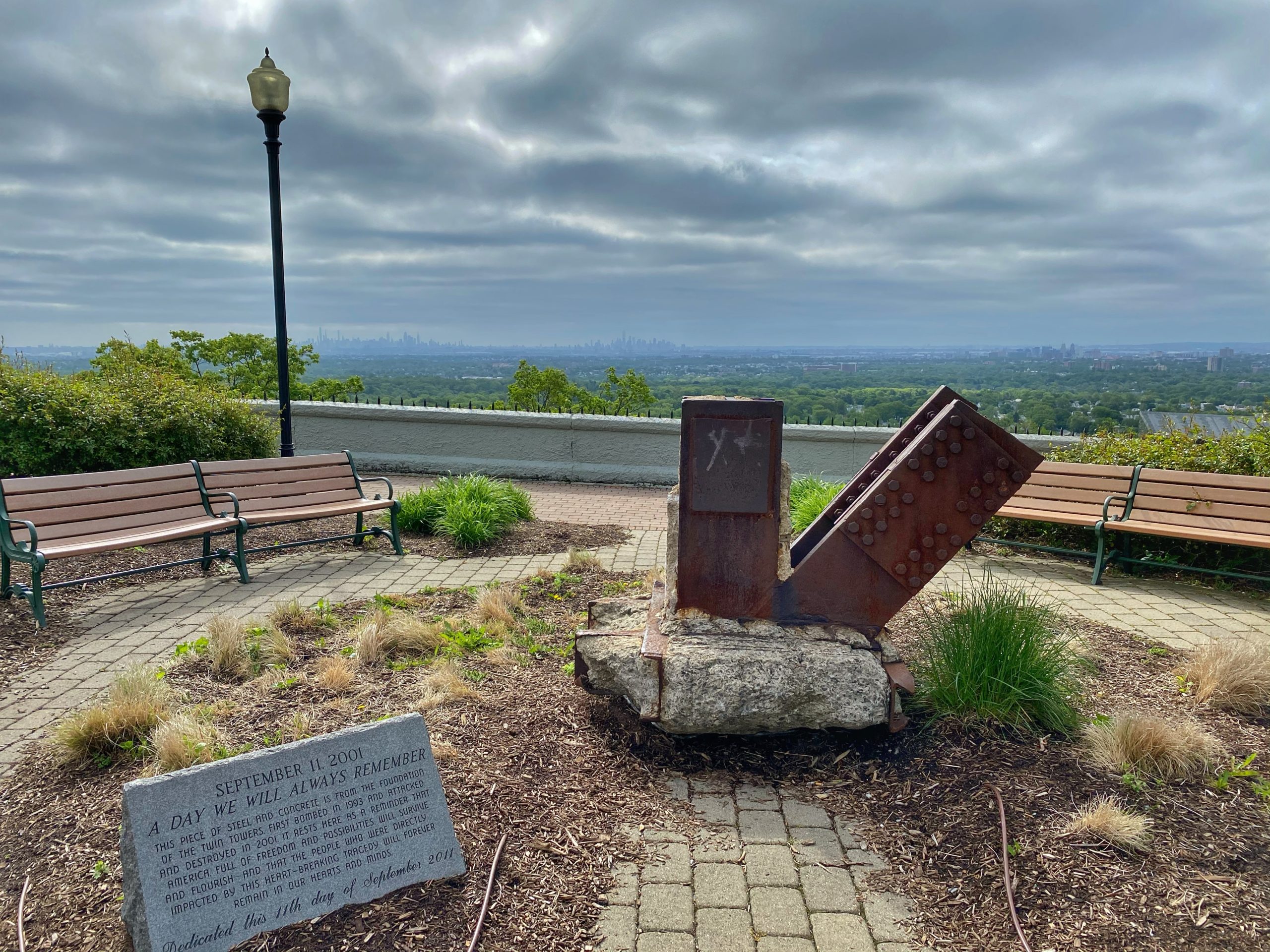
Eagle Rock Overlook: Formed by glaciers of the last ice age, this overlook on top of Orange Mountain provides sweeping panoramic views of the area, including the New York City skyline. From this vantage point, Washington’s army monitored British troop movements across the Hudson River during the American Revolution. In 1874, Alexander T. Compton began development of the Eagle Rock Resort, a year-round destination for city-dwellers to view nature and take in the fresh mountain air. In 1894, an electric trolley line was constructed to the base of the mountain, where visitors would then climb a wooden staircase known as the Hundred Steps to reach the top. When the Essex County Park Commission was formed in 1895, it protected the land at Eagle Rock from quarrying and residential construction. The old resort buildings were cleared and, in 1907, a spiked concrete wall was created to secure the edge. Today, the wall forms part of the boundary of the September 11th Memorial.
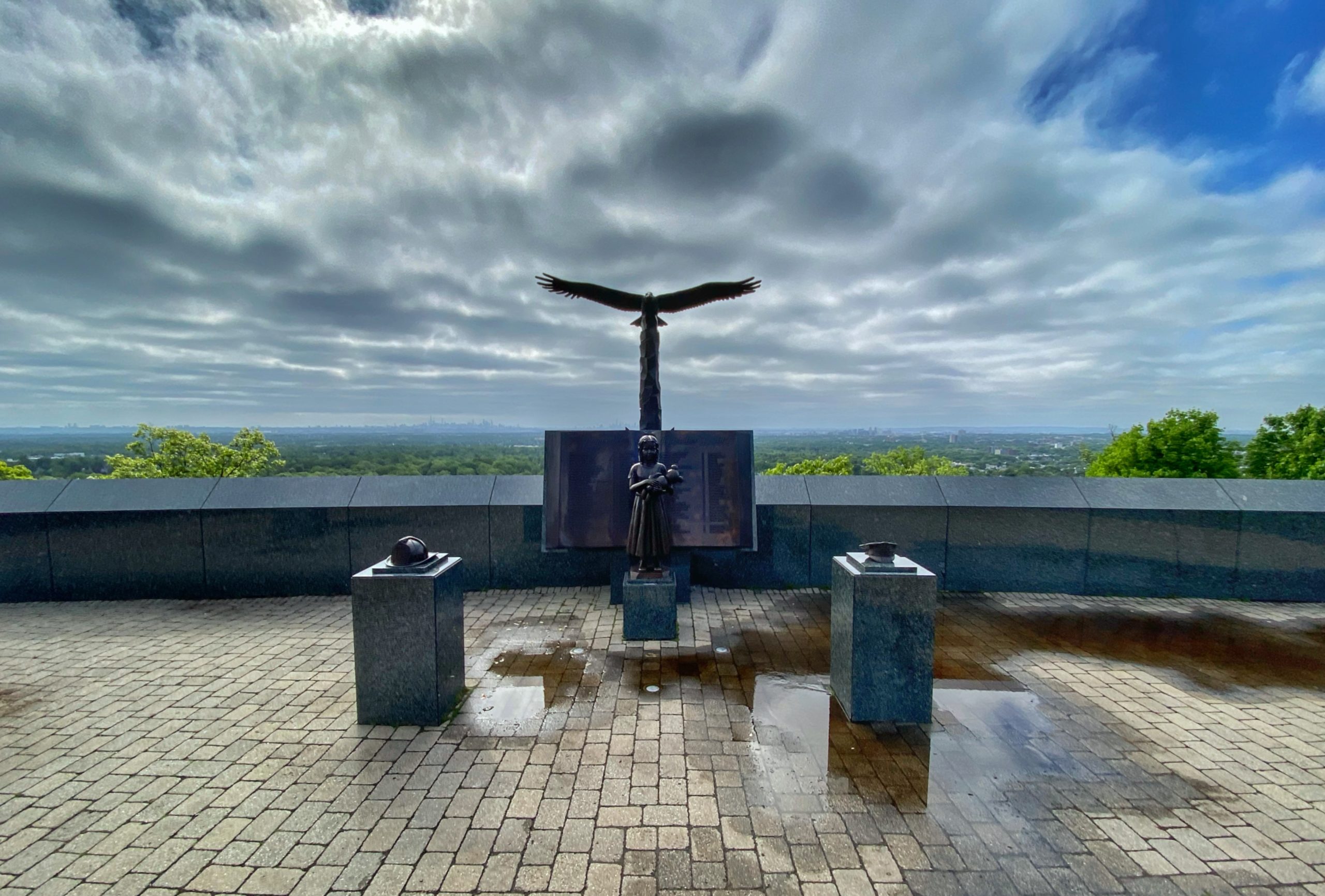
Essex County Eagle Rock September 11th Memorial: The Eagle Rock Overlook became a gathering place where thousands came to watch and pay respect to those who were lost on September 11, 2001. As word spread that this was a place where people gathered to grieve, to reflect, and to pay tribute, a spontaneous memorial of cards and candles, flags and flowers, photographs, prayers, and poems filled the wall overlooking New York City. Through funds raised by the County and the hard work of volunteers and family members, the Memorial was officially dedicated on October 20, 2002. At the center of the memorial is a 120-foot granite wall, carved with the 3,000 names of people who lost their lives. The site includes several bronze statues and a memorial grove of seven trees. In 2011, on the 10th anniversary of the attacks, a 7,400-pound steel and concrete piece of the World Trade Center foundation was installed along with a bronze plaque recognizing the bravery of emergency medical technicians. The memorial remains a special place where visitors find comfort and a tribute to resilience, peace, and hope.
-
Eagle Rock Overlook -
September 11th Memorial -
Eagle Rock Overlook
Mile 14 – Street walk through Verona
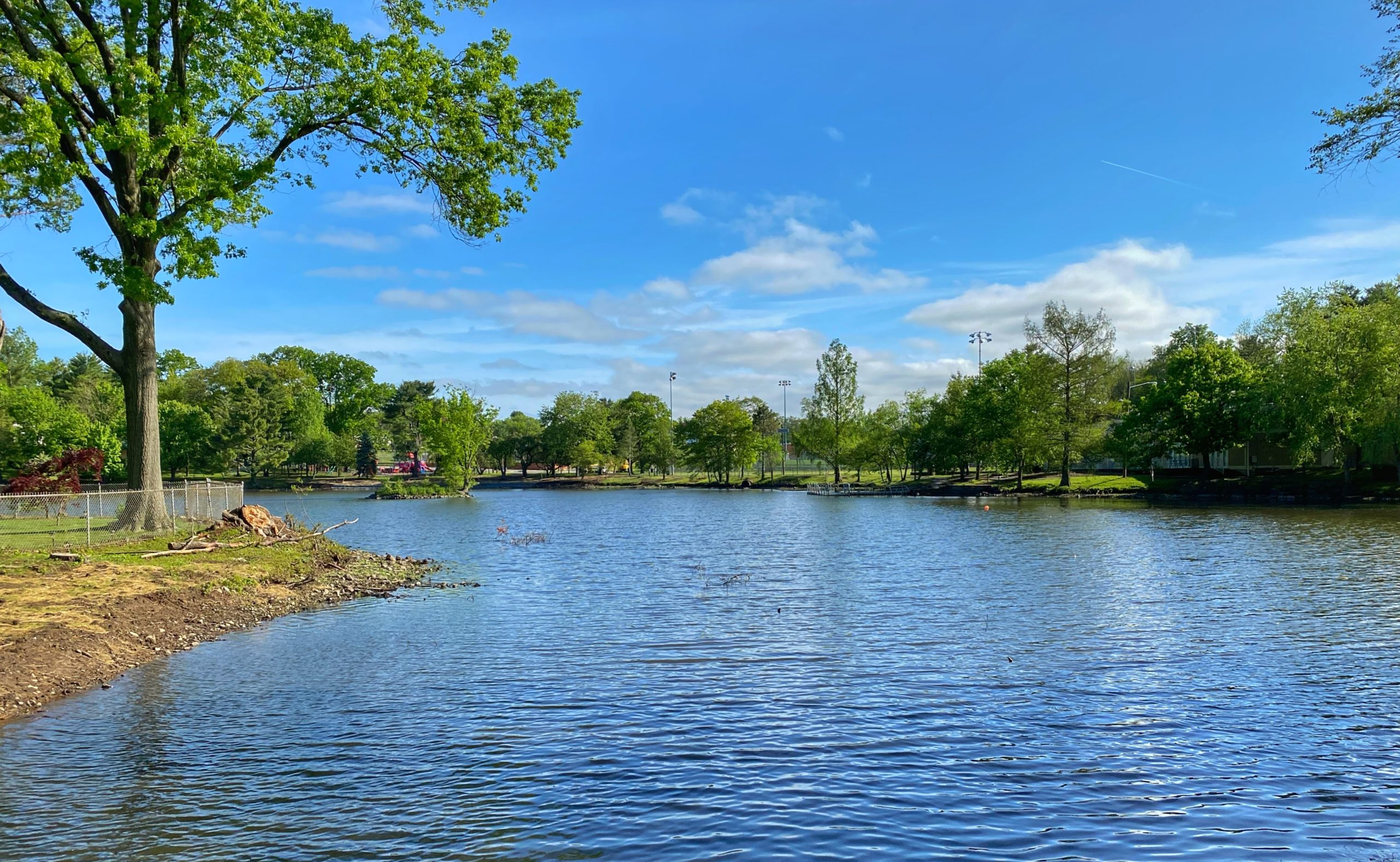
Mile 15 – Verona Park (Verona)
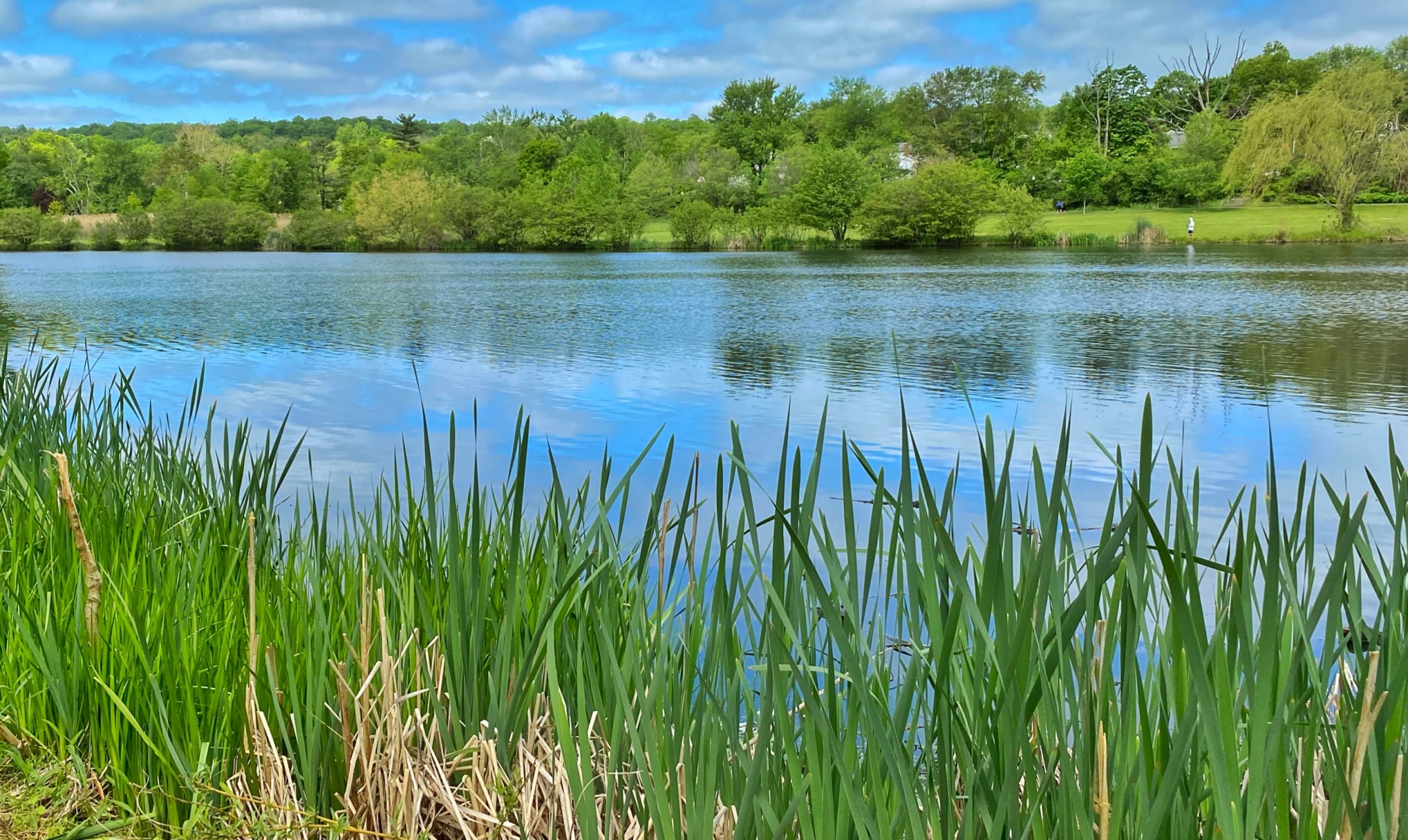
Verona Park is a picturesque park bordered by Lakeside and Bloomfield avenues in the southern part of Verona. The park features a large lake with paddleboats and a boathouse used for community events. It provides a welcoming habitat for many animals and birds such as white-tailed deer, eastern painted turtles, northern water snakes, double-crested cormorants, Baltimore orioles, egrets, mallard ducks, and red-winged blackbirds.
Once an old swamp, the lake in Verona Park was first formed in 1814, when the Peckman River was dammed for a gristmill. Later, Verona Lake, with its weeping willow trees and winding paths, became an ideal location for family activities, boating, bathing, skating, picnics, and band concerts.
The first land acquisitions for the park were made in 1920, and the landscape plans prepared by the Olmsted Brothers were approved the same year. To acquire part of this land owned by the Erie Railroad Company, an agreement was made that allowed the railroad to retain a right-of-way across the park, creating the island in the lake. However, the railroad bridge never materialized.
In 1995, a group of concerned citizens met to explore ways they could help restore Verona Park. As a result, a non-profit organization – the Verona Park Conservancy – was formed to restore the park to the design originally prepared by the Olmsted Brothers. Today, the conservancy works to maintain and enhance the park’s appearance and facilities, and also highlights its role in the community through the organization of concerts, craft fairs, and other events.
-
Verona Lake -
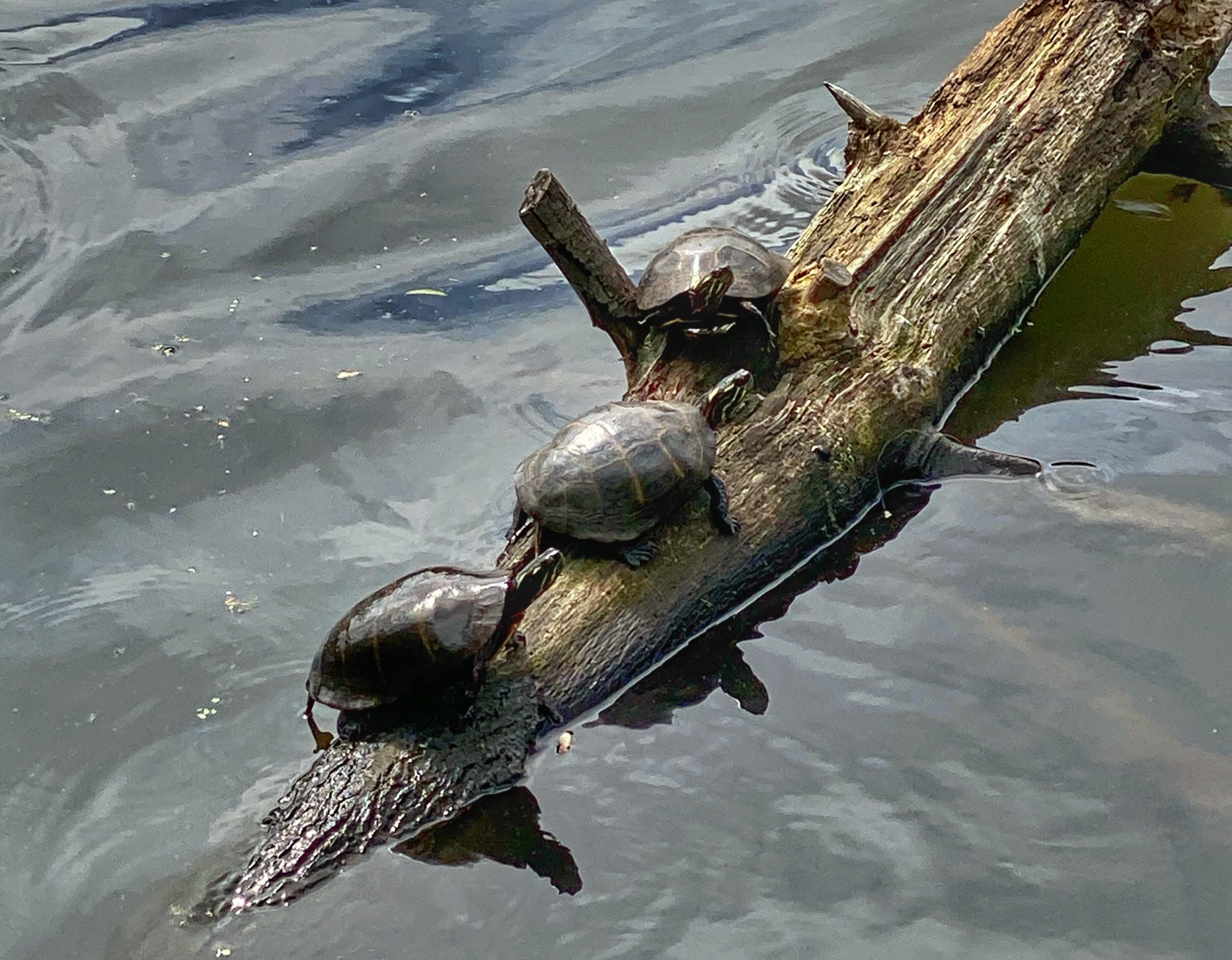
Turtles in Verona Lake
Mile 16.5 – Prisoner’s Pond, Hilltop Reservation
This spring-fed pond has fish, frog, and turtle residents, along with occasional ducks and herons. The pond is named Prisoner’s Pond after the Essex County Penitentiary that occupied the land around it for most of the 20th century. Built in 1872, it closed in 2004, prompting a rediscovery of the pond and efforts to reclaim the area. Most recently, the Hilltop Conservancy has embarked on a 5-year plan to regenerate 5 acres of area surrounding the pond with native trees.

Mile 17 – Grassland Meadow, Hilltop Reservation
Through the dedicated work of the Hilltop Conservancy, Hilltop has been restored as a wildlife habitat. The first habitat restoration project undertaken by the conservancy was the grassland meadows area formerly occupied by the Essex Mountain Sanatorium. The sanatorium buildings had been demolished by the time the Conservancy initiated the project in 2005, but the site was far from ready for planting. It took three full years of heavy cleaning and clearing work by volunteers before it was ready for seeding with wild grasses.
The Lenape Trail crosses the fully restored 15-acre grassland meadow which has become a habitat for birds and butterflies. The meadow features native grasses and wildflowers including switchgrass, indiangrass, big bluestem, little bluestem, asters, bee balm, lavender hyssop, milkweed, and wild senna. Hilltop Reservation’s location on the Second Watchung Mountain puts it in the middle of the Atlantic migratory flyway, providing great bird-watching opportunities year-round.
Mile 18.5 – Cedar Grove Park
Cedar Grove Park is the newest addition to the Essex County Park System, formally dedicated on December 12, 2016. The Robert J. O’Toole Community Center in the park was named for Robert O’Toole, the township’s retired three-term mayor. At 80 acres, it is one of the largest parks in the county parks system.
The park was developed on the site of the former Essex County Hospital Center, also known as the Overbrook Asylum. Adjacent to the community center are four bocce courts, three fitness stations along meandering paths, and a playground designed with a farming theme in recognition of the site’s history that included a farm to support the hospital.

Mile 19.5 – Cedar Grove Community Park
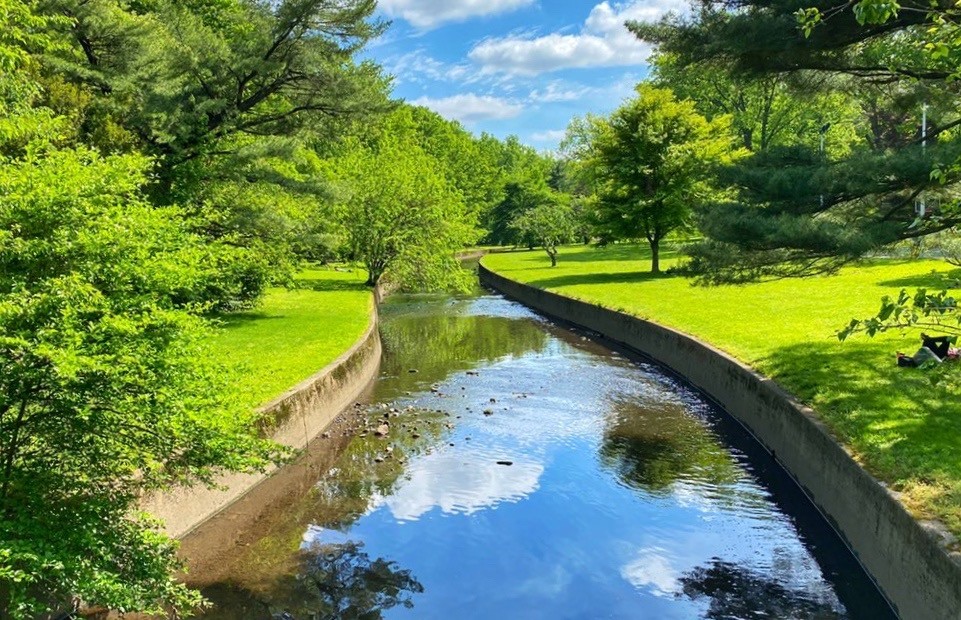
Cedar Grove Community Park is a municipal park bordered on the west side by the Peckman River and the east side by the West Essex Trail. The park has a variety of recreation facilities including two large playgrounds, two bocce courts, a softball field, a large grass field and garden, and a picnic area with a surrounding wooded area. Across the parking area is a large public pool with changing rooms and restrooms.
-
Peckman River -
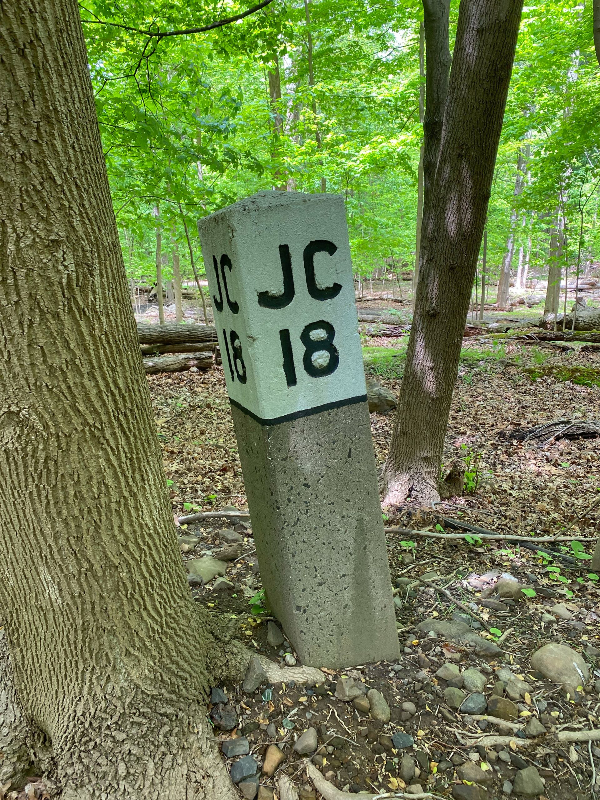
West Essex Trail, along the old Erie-Lackawanna railroad right of way, marking 18 miles to Jersey City
Mile 20 – 21.5 – Cedar Grove Reservoir
Not technically a park, the Cedar Grove Reservoir is owned by the City of Newark and limited public access – including the route of the Lenape Trail – is allowed for recreational purposes.
At the turn of the 19th century, a secure drinking water supply was needed for Newark’s growing population. Cedar Grove was selected as the site of the reservoir due to its proximity to the city and being close to a railroad for material transportation, but the location came with a challenge – most reservoirs are built in low valleys so that gravity helps water recharge the reservoir, while this project would be built near the top of a mountain. The construction of dams and pipelines to accommodate this challenge made the project more complicated than a typical reservoir.
Construction of the reservoir began in 1901, but it quickly encountered delays. Between challenging geology, worker strikes, malaria outbreaks, and a smallpox scare, the projected completion date of December 1902 quickly fell behind schedule. The reservoir finally held its formal opening in August 1905.
-
Cedar Grove Reservoir -

Cedar Grove Reservoir
Mile 21.5 – 22.5 – Mills Reservation
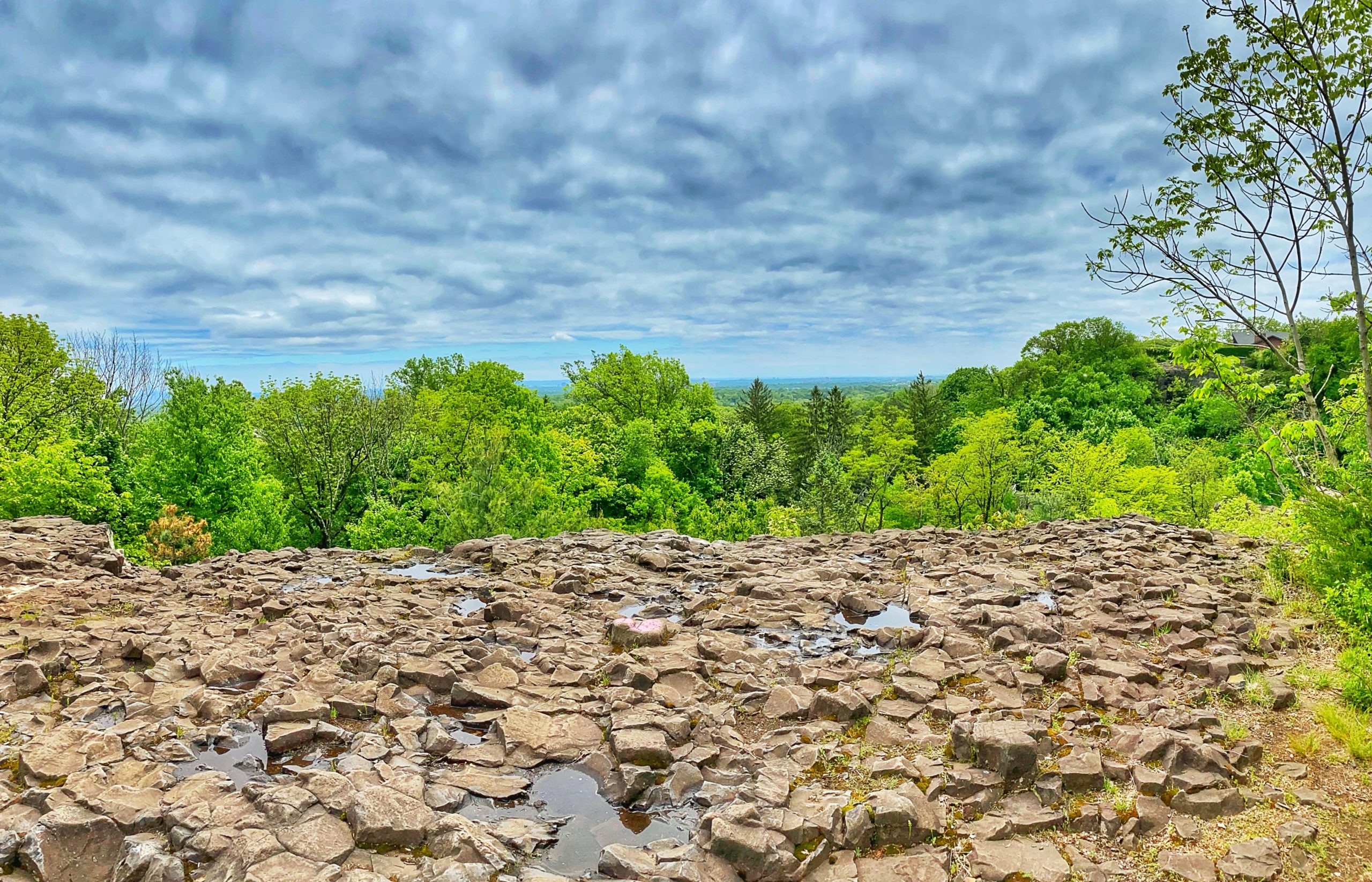
Mills Reservation is a protected 153.67-acre wooded area located on the First Watchung Mountain and bordering Cedar Grove Reservoir on the reservation’s northwest side. The parkland has been preserved in its natural state, including deciduous woodland and wetlands. It features several walking/jogging trails, including the Lenape Trail, that follow the eastern cliff and lead to an overlook with a sweeping view of the New York City skyline.
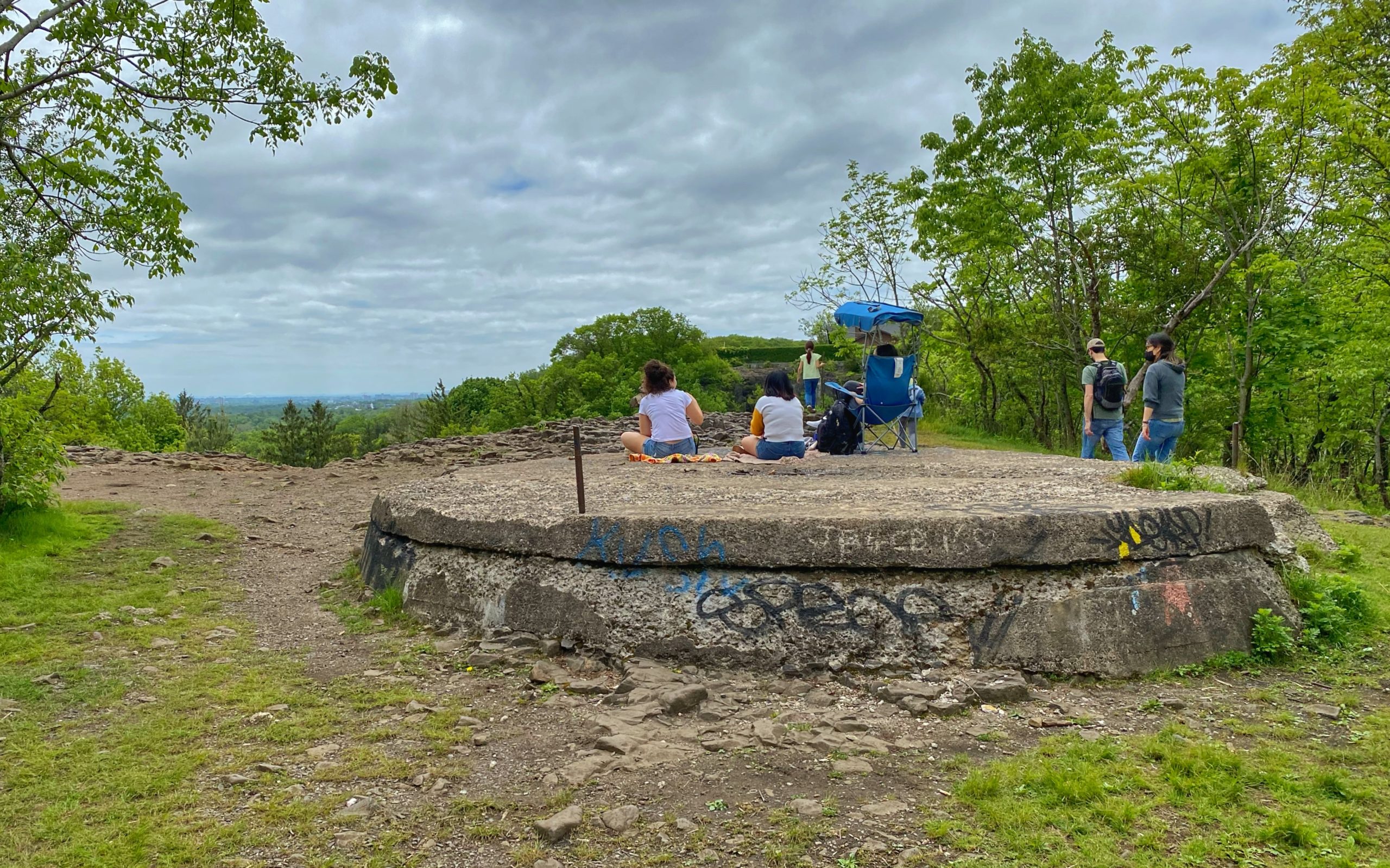
Settled centuries ago by Dutch families, much of this area was still owned into the 20th century by descendants of the Speer, Jacobus, and van Reyper families. In 1954, the Essex County Park Commission received a gift of 118.9 acres of what is now Mills Reservation from the Davella Mills Foundation led by David Mills, with the stipulation that the land be preserved in its natural state. The outcrop at Mills Reservation, known as Quarry Point, offers spectacular views of New York City and is considered one of the highlights of the reservation.
The cliff-edge overlook contains volcanic basalt outcrops in addition to a round cement platform, remains of the foundation for an anti-aircraft light installed during World War II. Earlier, the platform may have been the base of a water tower for the steam machinery and firefighting system of the former quarry of Osborne & Marsellis located below. There are also reports that the location was used as a firebeacon station in the French and Indian War, and earlier as a smoke-signal point by the Lenni-Lenape.
Quarry Point is well-situated for observing migratory birds. The New Jersey Audubon Society hosts their spring Hawkwatch at the site, while their fall Hawkwatch occurs on the opposite cliff outcrop across Old Quarry Road.
-
Quarry Point -

Quarry Point -
Foundation for a WWII anti-aircraft light
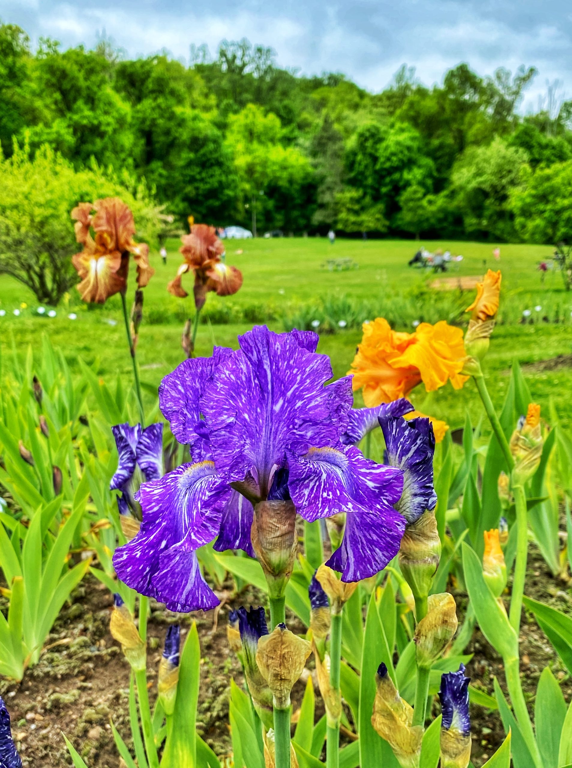
Mile 23 – Presby Memorial Iris Gardens
Located at the base of Mountainside Park, the Presby Memorial Iris Gardens contain over 10,000 individual iris plants which produce over 100,000 blooms. There are currently 26 beds containing historical bearded irises, as well as areas planted with non-bearded Spuria, Siberian, Japanese, and Louisiana irises. Some of the irises date back as far as the 1500s. The sweeping triangle of the beds, with approximately 1,500 different varieties of iris, creates a virtual rainbow on the hill each May. Over the decades, many volunteers have offered their time and talents to keep the irises blooming.
In the early 1920s, Frederick and Barbara Walther had mobilized residents to preserve undeveloped land north of their home on Upper Mountain Avenue as Mountainside Park. Frank Presby, a Montclair resident, horticulturist, and a founder of both the Montclair Art Museum and the American Iris Society, believed in beautifying the parks through flowers, trees, and blooming shrubs. After Frank Presby died in 1924, the Presby Memorial Garden was established in 1927. Members of the Montclair Art Museum and others, including Mrs. Walther, called for an iris garden in his memory on the hillside of the recently established park and John Wister, President of the American Iris Society, was engaged to design the garden.
A Citizens’ Committee with horticultural interests was recruited and Barbara Walther was appointed as its first chair. Their objectives were to create a picturesque landscape with the irises, to include new hybrids each year, and to be an educational resource. The nonprofit Citizens Committee maintained the gardens independently until 2009, when Essex County purchased the 12 acres with the house and grounds, saving the Gardens from an uncertain future and becoming a park in the Essex County Park System. Today, the Citizens Committee continues to maintain the plantings, manage operations, and carry out educational programming and cultural events on the grounds.
Mile 23.5 – Montclair-Boonton Line crossing at Mountain Avenue Station (Montclair)

Mile 24.5 – Tuers Park
Tuers Park is an 8-acre municipal park in the northern residential section of Montclair. It features a softball diamond, a basketball court, a children’s playground, and bikeways.
Mile 25 – Yantacaw Brook Park
Yantacaw Brook Park is an 11.5-acre municipal park located in Montclair, one block away from Brookdale Park. The park contains a small pond and a stream that attracts visiting waterfowl. Trees and low hills surround the pond, and there are paths and benches throughout the area. The Yantacaw Brook feeds the pond and then continues into the Third River through Bloomfield, Nutley, and Belleville, where it finally meets the Passaic River. Both Yantacaw Brook and the Third River were referred to by the Lenni-Lenape people as “Yantokah” or “Yantacaw.”
The park occupies the former site of the Upper Montclair Golf Club. In 2011, the Yantacaw Brook Park Conservancy was created to improve and enhance the park and its facilities. Conservancy members and volunteers work on projects such as keeping the park clean, planting flowers and shrubs, and protecting the park and its stream and pond from the introduction of invasive plants and animals.
-
Yantacaw Brook Pond -

Yantacaw Brook Park
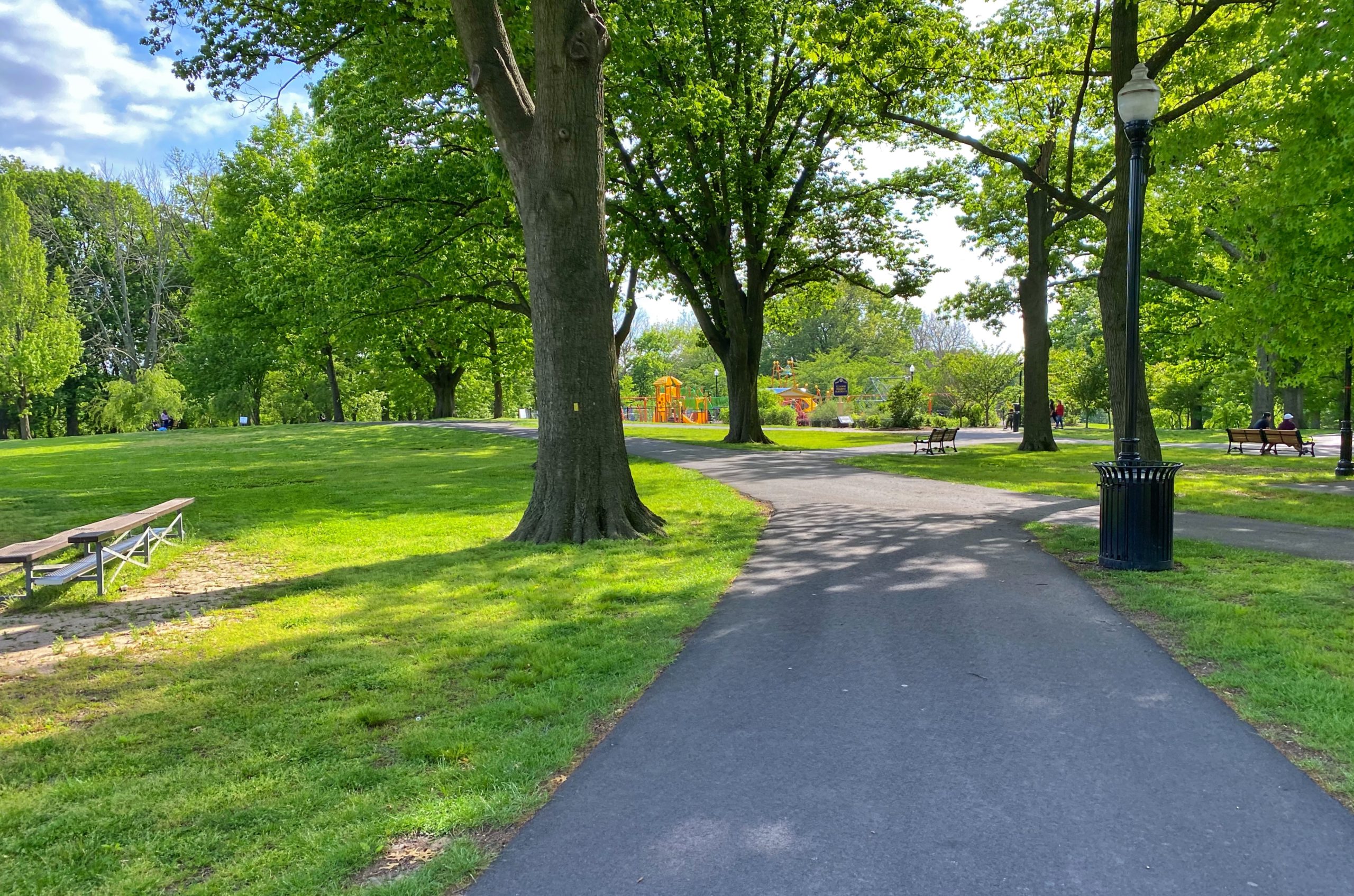
Mile 26 – Brookdale Park
Brookdale Park, designed by the world-renowned Olmsted Firm, is one of the larger parks in the Essex County Park System. With a total of 121 acres – 78 acres in Bloomfield and 43 acres in Montclair – it is one of the most heavily visited parks in the county. It features open vistas, a deep forested area, open lawns, lush gardens, sports fields, track facilities, tennis courts, an archery range, a playground, and a stadium with grandstand.
Several gardens can be found throughout the park. One of its most notable attractions is the Essex County Rose Garden established in 1959 through a joint effort of the New Jersey Rose Society and the Essex County Parks Department. The garden has grown to include 1,500 rose bushes, including nearly 100 different varieties, and the 29 separate beds are maintained by volunteers from the Master Gardeners of Essex County. Planted in the spring of 2018, the new pollinator garden provides food and habitat for butterflies, bees, and other pollinating insects. The Cherry Lawn currently showcases some of the park’s original cherry trees as well as recently planted successor trees. Brookdale Park offers over 200 acres of varied wildlife habitat and hosts a great number of bird species from the common house sparrow to the occasional wild turkey.
Brookdale Park is located in what once was a gathering place for the Lenni-Lenape. During the 17th century, Dutch settlers transformed the area, then called Stonehouse Plains, into farming and grazing land. In the 1800s, when the area received its own post office near the Third River, the neighborhood came to be known as Brookdale. In 1928, land purchases began for the park, but the onset of the Great Depression caused construction schedules to slow as money was needed elsewhere. As unemployment spread, agencies such as the federal Works Progress Administration (WPA) were organized and subsequently provided most of the funding and labor needed to construct the park’s landscape.
Today the volunteers from the Brookdale Park Conservancy, in partnership with Essex County and the Rutgers Master Gardeners of Essex County, work on landscape restoration and park enhancement as well as sponsoring community outreach programming and events.
-

Essex County Rose Garden -
Brookdale Park
Mile 27 – Clark’s Pond Preserve
While technically not a formal park, Clark’s Pond Preserve is a valuable green respite with waterside paths. Fed by the Third River, this pond and nature preserve is home to a wide variety of wildlife. There are deer, fox, wild turkey, egrets, and blue heron among other animals that live in the preserve. The pond is a favorite spot for fishing, where you can find bass, sunnies, carp, catfish, perch, and some trout. There is a path that follows one side of the pond, a small picnic area, and a pedestrian bridge over the river.

Mile 27.5 – Garden State Parkway Pedestrian Overpass
Mile 29 – Yanticaw Park (Nutley)
Yanticaw Park is located in the Township of Nutley. It is a mid-sized park, encompassing 28.75 acres and bisected by the Third River. A park drive separates the picturesque valley created by the river from the upper flatland where there are several ball fields.
The park name is of Native American derivation. The name “Yanticaw,” widely used throughout the town of Nutley, has its origins from a local Native American ceremonial dance of thanksgiving called Yantacaw. It stems from the Lenni-Lenape words meaning “place of the wood boundary.” The Lenni-Lenape people traditionally made an annual trek to the seashore to catch fish and to gather shells used for cooking and eating utensils. On their way, they gathered at a spot where the present Third River — recorded as “Yountakah” on a 1666 deed made between Captain Robert Treat and the Lenape people — flows into the Passaic River in Nutley.
In 1895, John R. Clark and Dr. Thomas E. Satterthwaite campaigned ceaselessly for the creation of a park here. Actual acquisition of the park started in 1911, and by 1914 Yanticaw Park became a reality. The swampy lowlands were drained, a dam was built to create a lake (later removed), and paths were laid out following the design of the Olmsted Brothers.
A renovation in 2010 updated the playground, restroom facilities, two softball fields, and a large grass baseball field. The park is the site of town-sponsored events and festivals.
Mile 29.5 – Booth Park (Nutley)
Booth Park, a Nutley Township park, covers slightly over 13 acres and is located between Centre and Harrison streets, extending the green corridor from the southern portion of Yanticaw Park. The Third River flows south through the park alongside amenities including a universal playground area, a baseball/softball field, a soccer/lacrosse field, and a picnic area.

Mile 31.5 – Belleville Park
Belleville Park is a mid-sized, 32.70-acre park of wooded greenery bordered by Belleville Avenue, Parkside Drive, and Mill Street along the Second River. The park is contiguous with Branch Brook Park, creating a continuous green strip over 2.5 miles long. The land for the park was acquired in 1915, with construction completed in 1922. The Olmsted Brothers firm designed the park, and even today it retains some of the original landscaping in its sweeping lawns and winding paths. Some of Branch Brook’s famous “Cherry Blossom Land” overflows into this park. Next to the park is Hendricks Field Golf Course, extending the green landscape farther northward.
Coniferous trees divide the park into sections and isolate it from the city streets, creating a shaded, quiet path along the river. Its semi-formal character is derived from plantings of native, rare, and ornamental trees and shrubs. The open field areas provide feeding habitats for small mammals and migratory birds. In 1917, to aid in the war effort, these fields were temporarily planted with corn.
Encompassing land that included a number of former industrial sites, the park represents an early example of urban rehabilitation. A shallow depression by the south side of the park represents all that is left of an old rock quarry.
Mile 32-36 – Branch Brook Park (Newark)
Branch Brook Park is distinguished as the first county park opened for public use in the United States. Located in the City of Newark, the park is nearly 4 miles long and averages 1/4 mile in width. Begun in 1895, it now encompasses 360 acres and is the largest developed park in Essex County. The park is a combination of open meadowland and small patches of woodland on gently rolling terrain with meandering streams and ponds. A major highlight of the park is the cherry tree collection of over 5,000 flowering cherry trees, the largest and most varied collection in the United States. The annual Cherry Blossom Festival attracts approximately 10,000 visitors each April. The park also features many architecturally significant bridges, buildings, gates, and sculptures.
The first designs of the park, based largely on romantic garden themes, were proposed in 1895 and 1898. In 1900, the Parks Commission hired the Olmsted Brothers firm to redesign the park with a more natural feel, similar to their father Frederick Law Olmsted’s work on Central Park. The park doubled in size between 1924 and 1929 to become one of the largest “city” parks in the country.
The park is named for Branch Brook, a tributary of the First River that flows from north to south in the valley where the park lies. As it flows, it opens into a string of beautifully designed ponds and pools. In between the ponds are eight bridges designed using local brownstone and glacial boulders to blend into their surroundings. Continuing south leads into an urban forest with many native trees, shrubs and perennials. The southern portion of the park features the 24-acre Branch Brook Lake, which is stocked with trout. Small islands in the lake attract aquatic birds, and the lakeshore is lined with plantings and architectural features including the Prudential Lions and the Octagon Shelter. In addition to its natural beauty, artistic structures, and vegetation, the park features a roller-skating rink, a fitness course along the winding park path, baseball and softball fields, and tennis and bocce courts.
Today the Branch Brook Park Alliance (BBPA), a public/private partnership organized in 1999, provides design expertise and funding support to help Essex County restore and revitalize the park. Together with the Essex County Department of Parks, Recreation and Cultural Affairs, the BBPA hosts festivals, events, movies, dances, and concerts in the park.
Mile 36 – Cathedral Basilica of the Sacred Heart (Newark)
Visible from the end (or start) of the Lenape Trail, the Cathedral Basilica of the Sacred Heart is the fifth-largest cathedral in North America and is the seat of the Roman Catholic Archdiocese of Newark. Designed in the French Gothic Revival style, construction on the Cathedral began in 1899 and was finished in 1954.


