• Best Hikes in NJ
  • Find a Hike
    • Search/Find a Hike
    • Hike Map
    • Most Popular Hikes
    • Best Kid-Friendly NJ Hikes
    • NJ Hikes
    • NY Hikes
    • John Muir Trail
      • Part 1: Reds Meadow to Yosemite Valley
      • Part 2: Duck Pass to Bishop Pass
      • Part 3: Bishop Pass to Mt. Whitney
    • Appalachian Trail
    • Other
      • Barataria Preserve
      • Coconino National Forest
      • Grand Canyon National Park
      • Great Smoky Mountains National Park
      • Inyo National Forest
      • John Muir Trail
      • Shenandoah National Park
      • Yellowstone National Park
      • Yosemite National Park
  • Tips & Essentials
    • Hiking for Beginners
    • Best NJ & NY Hiking Books & Resources
    • Best Hiking Apps
    • AllTrails vs GaiaGPA
    • Hiking Gear
    • Winter Hiking Tips
    • Pequannock (Newark) Watershed Permits
    • Trail Maintenance Gear
    • Leave No Trace
  • Contact
Take a Hike!
Of all the paths you take in life, make sure a few of them are dirt. -John Muir
Bear Mountain State ParkNew York

Popolopen Torne Loop – Bear Mountain State Park

by Juan Melli October 13, 2019
by Juan Melli October 13, 2019 0 comment

Overview: Popolopen Torne or just “The Torne” is a small mountain with a bald top. After a steep hike along the Time-Torne Trail in which you’ll gain 500 feet in less than half a mile, you’ll be rewarded with panoramic vistas of the Hudson River, West Point, Bear Mountain, and Harriman State Park. At the top is a stone cairn memorial to fallen U.S. service members. You can carry a rock uphill to add to the cairn, which has been getting larger each year.

Hike Length: 1.2 miles (or 4.3 miles if you park in the hiker lot on Rt 9W)

Elevation gain: 615 ft

Location: Bear Mountain State Park, Palisades Parkway or Rt 9W North, Bear Mountain, NY. Driving directions.

Nearby hikes: Bald Rocks & Hogencamp Mountain, Harriman State Park 

Parking: For the shortest hike, park at the Popolopen Torne Trailhead Parking lot located at 288 Mine Rd, Highland Falls, NY (Note: there is only space on the side of the road for a few cars). Otherwise, you will need to park in the hiker lot located 0.3 miles north of Fort Montgomery parking lot on Rt 9W. Please observe the signage directing hikers to the hiker lot down the road and do not park in the Fort Montgomery lot where the visitor center is located. Note that this parking lot does not appear on the park’s official map.

Map: Bear Mountain State Park map

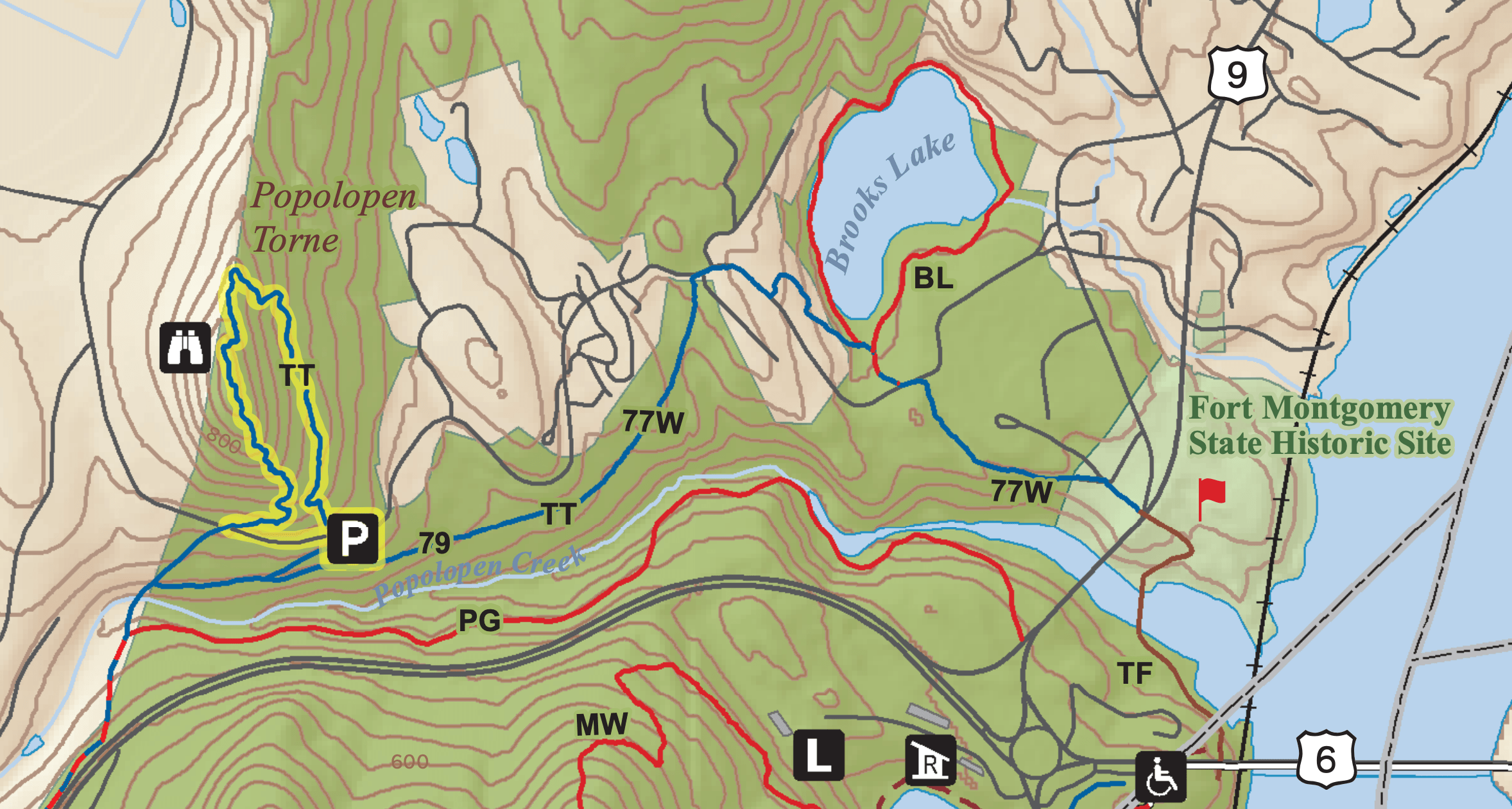
Trail Description (from Popolopen Torne Parking lot): From the parking lot, walk west along Mine Rd. On your right, you will see a blue blazed trail, but keep walking (this is the way you will be coming down). After about 800 feet total from the parking lot, you will again see the blue trail on your right. Follow the blue-blazed Timp-Torne (TT) Trail to the top and back down, ending at Mine Rd near the parking lot. 

Trail Description (longer version, from Rt 9W hiker lot): From the parking lot, walk south on Rt 9W, across the Popolopen Bridge. Soon after crossing the bridge, look for the trail on your right marked by the three red on white blazes. This is the start of the Popolopen Gorge Trail. Follow this trail for 1.6 miles. Turn right on the 1777W/1779/Blue trails. Turn left on the Blue Trail. Cross a gravel road and continue on the Blue Trail then go over or under a guard rail and continue on the Blue Trail. After a short but strenuous stretch, you’ll reach the summit with spectacular views.

To head down, continue straight across the summit along the Blue Trail. Follow the Blue Trail until you reach the paved Mine Road, then make a left. Turn right into the parking area and continue to follow the Blue blazes along the gravel road. Continue to follow the Blue Trail as it forks left from the gravel road. The Blue Trail will rejoin 1777W and 1779 trails. Continue for about a mile. When you reach the paved Mine Road again, turn right. Continue to follow the Blue/1777W/1779 blazes and markers. After about 5 minutes, turn left onto the Blue/1777W/1779 trail into the woods. At the Red on White/Blue/1777W/1779 junction, turn right. Then turn left on the paved road, then turn right to stay on the Blue/1777W/1779 trail. Continue to follow the Blue/1777W/1779 blazes to return the Fort Montgomery site. Walk through the site to reach Rt 9W and continue a quarter mile north to the hiker lot. 

Share 0 FacebookTwitterPinterestLinkedinEmail
Juan Melli

Juan lives in Hoboken, New Jersey with his wife and two boys. He likes to explore the great Garden State and other equally nice states.

previous post
Anthony’s Nose (Unofficial scramble)
next post
Storm King Mountain & North Point

You may also like

Bradley Mine – Harriman State Park

May 3, 2022

Black Rock Mountain & Stahahe High Peak –...

February 27, 2022

Cat Rocks, Eastern Pinnacles & Fitzgerald Falls –...

January 17, 2022

The Best New Jersey and New York Hiking...

January 12, 2022

High Tor – High Tor State Park

December 4, 2021

Hook Mountain and Nyack Beach Loop

November 21, 2021

Eagle Cliff and Copes Lookout – Mohonk Mountain...

November 13, 2021

Bear Hill Preserve & Grapefruit Squeeze

October 29, 2021

Labyrinth and Lemon Squeeze – Mohonk Mountain House

October 24, 2021

West Mountain, The Timp, Bald Mountain & Doodletown...

October 11, 2021

Leave a Comment Cancel Reply

You must be logged in to post a comment.

Search

Top NJ Hikes This Week

  • 1

    Hemlock Falls – South Mountain Reservation

  • 2

    Lenape Trail

  • 3

    Paterson Great Falls National Historical Park

  • 4

    High Rocks – Johnsonburg Swamp Preserve

Top NY Hikes This Week

  • 1

    Bradley Mine – Harriman State Park

  • 2

    Doris Duke Trail – Sterling Forest State Park

  • 3

    Cat Rocks, Eastern Pinnacles & Fitzgerald Falls – Appalachian Trail

  • 4

    Mt. Beacon Fire Tower – Hudson Highlands State Park Preserve

About Me

About Me

Juan

I love the outdoors. Over the years, friends would ask me for tips on where to hike, so I started this website as a way to help others discover nature.

Through the New York-New Jersey Trail Conference, I'm a volunteer maintainer of a section of the Appalachian Trail (Garvey Springs to Kaiser Road) - which includes the beautiful Raccoon Ridge - in the Delaware Water Gap. I'm also a Trustee and Vice President of the Board of Team Wilderness, a non-profit with a mission of growing teamwork, leadership, and character within our urban youth through wilderness excursions.

Questions? Angry Rants? Jell-O recipes? I can be reached by using this form.

Facebook Twitter Instagram Youtube
  • Garnet Lake
  • Looking north from Pinchot Pass
  • Woods Creek Suspension Bridge
  • Facebook
  • Twitter
  • Instagram
  • Youtube
Take a Hike!
  • Best Hikes in NJ
  • Find a Hike
    • Search/Find a Hike
    • Hike Map
    • Most Popular Hikes
    • Best Kid-Friendly NJ Hikes
    • NJ Hikes
    • NY Hikes
    • John Muir Trail
      • Part 1: Reds Meadow to Yosemite Valley
      • Part 2: Duck Pass to Bishop Pass
      • Part 3: Bishop Pass to Mt. Whitney
    • Appalachian Trail
    • Other
      • Barataria Preserve
      • Coconino National Forest
      • Grand Canyon National Park
      • Great Smoky Mountains National Park
      • Inyo National Forest
      • John Muir Trail
      • Shenandoah National Park
      • Yellowstone National Park
      • Yosemite National Park
  • Tips & Essentials
    • Hiking for Beginners
    • Best NJ & NY Hiking Books & Resources
    • Best Hiking Apps
    • AllTrails vs GaiaGPA
    • Hiking Gear
    • Winter Hiking Tips
    • Pequannock (Newark) Watershed Permits
    • Trail Maintenance Gear
    • Leave No Trace
  • Contact