Overview: This 5.8 mile loop passes a dramatic 25-foot waterfall and Washington Rock, where a 1780 bonfire warned the Continental Army about a British attack.
South Mountain Reservation is an oasis of wilderness in an urban sea. One of America’s first parks and the largest in the Essex County Park System, the 2,110-acre park include hills, rivers, and woodlands, with 50 miles of trails, vistas of New York City, a dramatic 25-foot waterfall at Hemlock Falls, the cascade of Maple Brook in the deep woods, and millponds, streams, and picnic areas and open fields in the interior valley.
Hike length: 5.8 miles
Elevation gain: A few hundred feet.
Location: South Mountain Reservation, Millburn, Essex County, NJ
Parking: Locust Grove parking lot, just down the road and across the street from the Millburn Public Library in Millburn, NJ.
Map: The online map is not very good. The South Mountain Conservancy sells color, waterproof maps and trail guides. Color maps are also posted at trail heads (take a photo with your phone).
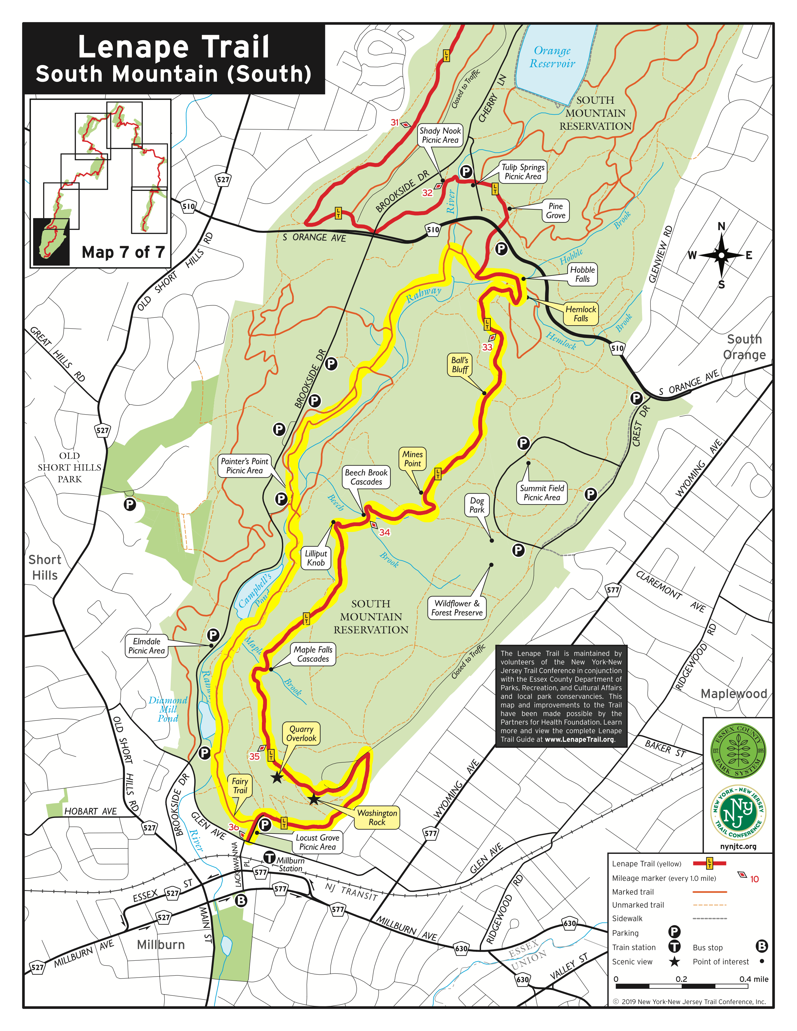 Trail description (with mileage), adapted from Hiking New Jersey – A guide to 50 of the Garden State’s Greatest Hiking Adventures:
0.0 At the far end (northeast) of Locust Grove Parking Area, locate the junction of the three carriage roads (now called trails). Take the right prong onto the Lenape Trail (yellow blazes) and ascend up a gravel path into the picnic grove.
0.1 Cross to the back left (east) corner of the picnic area on a grassy footpath, watching carefully for the yellow blazes. Enter the woods on a path and begin to climb the First Watchung Mountain.
0.3 Arrive at a chain-link fence. Turn right (east), continuing through a hardwood forest.
0.5 Just before the crest, turn left (west) off the path and onto a forested trail.
0.6 At the T intersection turn left (southwest) onto paved Crest Drive (closed to vehicles). Yellow blazes are scarce, but one is found on an oak tree 50 yards up the road. Shortly pass a green-blazed trail on your left.
0.7 At the end of the stone guardrail, and before the Washington Rock Monument, the Lenape Trail leaves Crest Drive veering left. Continue straight along the Watchung ridge, descending to a lookout and eventually descending stairs. (Side trip: Explore the Washington Rock monuments and interpretive kiosks).
0.8 Pass a series of unofficial trails to the left, leading to the top of the quarry (fenced).
1.0 Cross (north) Sunset Trail (bridle path) and ascend into a hardwood forest.
1.3 The Lenape Trail carves its way along a bowl, arriving at Maple Falls Cascades (seasonal).
1.6 Cross (east) Pingry Trail (bridle path), passing some mighty tall oaks.
2.0 Arrive at Lilliput Knob, where the trail swings across a cobble field before descending.
2.2 Arrive at Beech Brook Cascades (seasonal), crossing two streams above the gorge. The trail swings away and parallels the brook.
2.4 Cross (east) Overlook Trail (bridle path) and ascend through rubble as the route rambles northwest.
2.5 Arrive at Mines Point. The top of the ridge has been devastated by gypsy moths.
2.9 Arrive at Ball’s Bluff. The stone pillars are all that remain of a 1908 picnic pavilion. Beyond the ruins, the trail descends and turns left (north) before Ball’s Bluff Trail (bridle path).
3.0 Cross (northeast) Ball’s Bluff Trail and descend along a brook, which the trail eventually crosses.
3.4 At the T intersection with the Openwood Trail (bridle path) turn right (east) and ascend on the Lenape Trail while the Openwood Trail turns right (southeast). Shortly the Lenape Trail veers right (south) off a point and into a hollow.
3.5 Arrive at Hemlock Falls and a stone pedestrian bridge. Cross the bridge and turn left (north) onto Lenape Trail. (Side trips: Turning right brings you to the base of the falls. Continuing straight onto the Red Dot Trail brings you to the top of the falls.)
3.6 At the triangle veer left (west). At the T intersection at the base of the triangle, turn left (southwest) onto River Trail, an old bridle path without blazing. The route immediately crosses a stone bridge, the Openwood Trail coming in on the left. (FYI: The Lenape Trail veers right at the triangle and, at the base of the triangle, brings you to the Rahway Trailhead).
3.7 As the River Trails climbs out of the bottomland, arrive at a “turtle back” ledge 30 feet above the Rahway River, a good lunch spot. Continue heading south.
3.8 Pass Ball’s Bluff Trail on the left (southeast)
4.0 Leaving the River Trail, turn right (north) onto a gravel road and walk 50 feet, stopping before the bridge abutment, turn left (west) onto the Rahway Trail (white blazes). The trail drops down along the Rahway River’s bottomland. (FYI: Following the white blazes brings you back to the Locust Grove Parking Area).
4.3 Cross woods road. Dam on right.
4.5 Pass a dam on right with a bridge leading to Painter’s Point.
4.6 The Rahway Trail and the River Trail (bridle path) begin to crisscross, merge, and path more times than you want to count. Seems a little ridiculous. From the rhododendron grove, you can take either the River Trail or the Rahway Trail till you cross the stone bridge.
4.7 The brick plant and Campbell’s Pond are below on your right; turn right (west) onto the Rahway Trail, following it back down toward the river. Stick with the white blazes.
5.0 Forty feet above the Rahway River, the trail traverses the bank before crisscrossing a tributary on a beautiful stone bridge.
5.3 Crisscross River Trail three more times before passing Diamond Mill Pond/Dam on the right.
5.8 Arrive at the northwest side of Locust Grove Parking Area.


