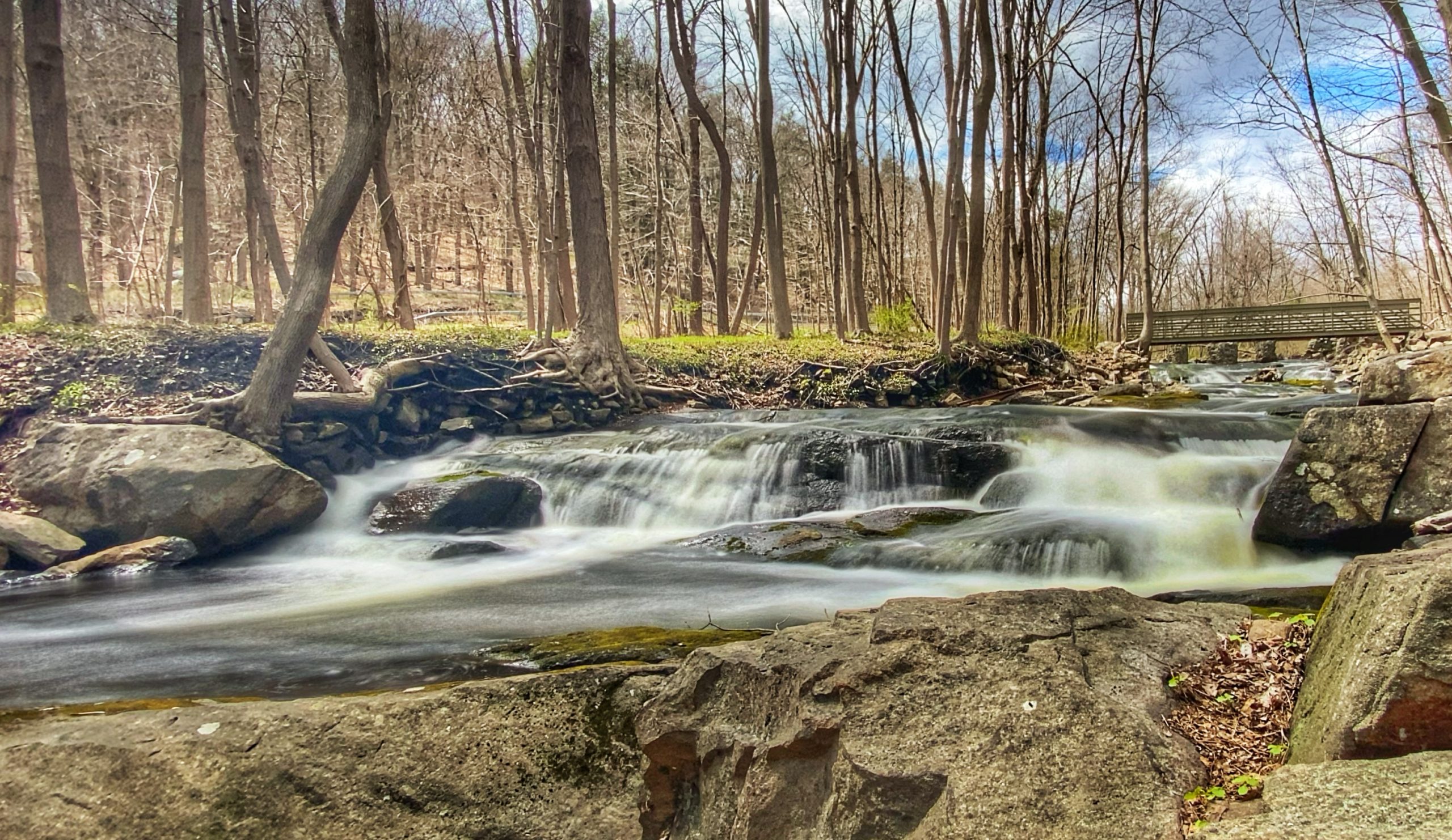
Overview: This loop crosses a picturesque cascading creek, passes the remains of a historic iron furnace, and offers several viewpoints over Sterling Forest, the Ramapo River Valley, and Harriman State Park.
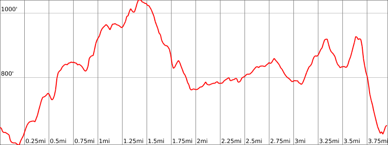
Hike Length: 4.3 miles
Elevation gain: +1,010 feet
Location: Sterling Forest State Park, Tuxedo, Orange County, NY
About Sterling Forest State Park: The park comprises almost 22,000 acres of nearly pristine natural refuge amidst one of the nation’s most densely populated areas. This unbroken deep-forest habitat is important for the survival of many resident and migratory species, including black bear, a variety of hawks and songbirds and many rare invertebrates and plants.
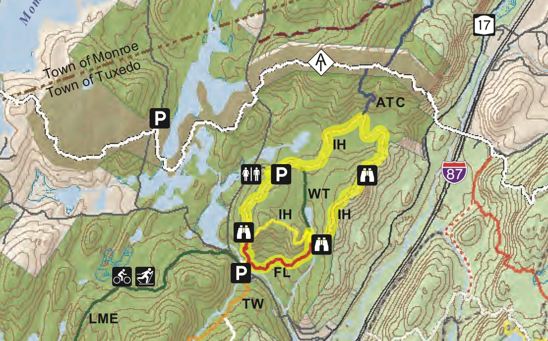
Parking: Park in the side of the road on Hall Drive. GPS Address: Hall Drive, Tuxedo, NY 10975
Map:
- Sterling Forest State Park (NY State Parks)
- NY-NJ Trail Conference Sterling Forest Trails (Trail Map #100)
- National Geographic – Harriman, Bear Mountain, Sterling Forest State Parks Map
Trail Description (from 50 Hikes in the Lower Hudson Valley):
From the parking area, proceed ahead (north) on Hall Drive, following the white blazes of the Wildcat Mountain Trail. When you reach Orange Turnpike, turn right and cross the road, climb over the guardrail, and descend to cross a footbridge over Mombasha Creek.
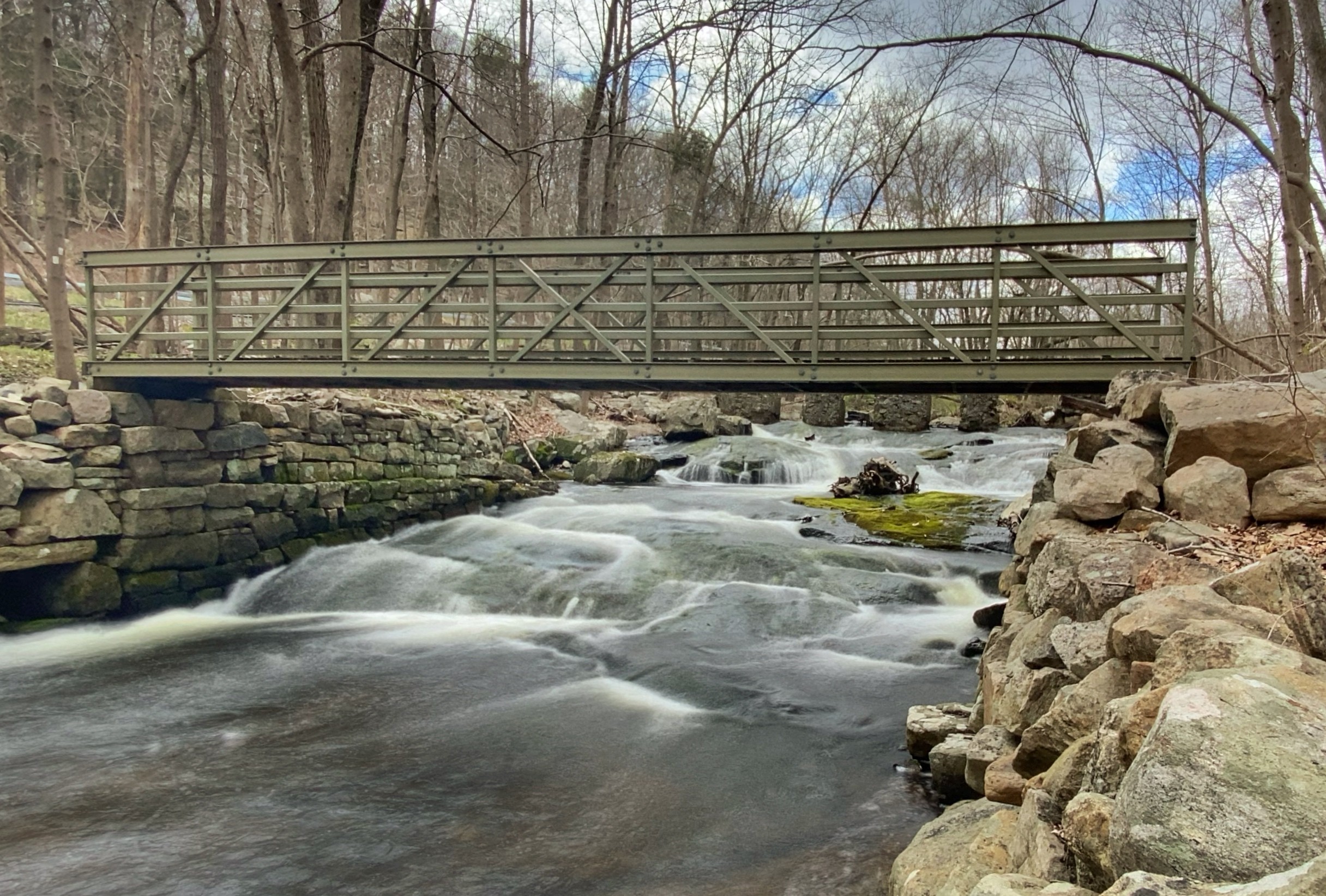
The trail now turns right and heads east, parallel to the stream.
Just beyond, the white-blazed trail ends, and you should continue ahead on the red-blazed Furnace Loop Trail. You now approach the historic Southfields Furnace, protected by a chain-link fence.
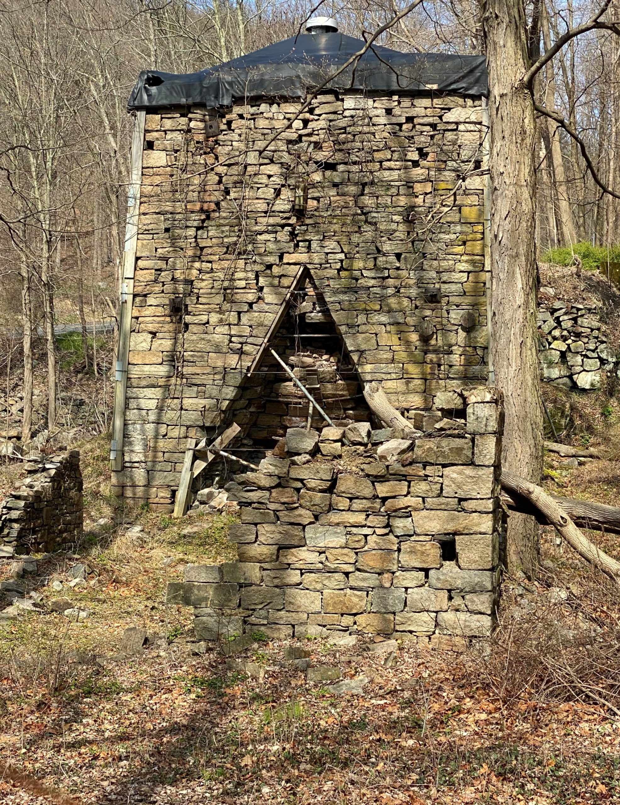
Construction of the first furnace on this site began in 1804, and the furnace was “in-blast” about a year later. By 1868, Southfields Iron Works complex comprised not on a furnace but also a blacksmith shop, stamping mill, sawmill, gristmill, wheelwright, branch rail line, and manor house, among other facilities. Although the charging bridge (supported by arches) and some of the walls of the casting room remain intact, the furnace has suffered decay from neglect and weathering. Its “last blast” was in the fall of 1887. The complex was acquired by the Scenic Hudson Land Trust in 1997 and was transferred in 2002 to the State of New York for inclusion in Sterling Forest State Park.
Some 100 to 200 years ago, iron was produced in stone furnaces, like Southfields, by mixing iron ore, charcoal, and limestone. Once a furnace was lit, the blast would run continuously, producing as much as 25 tons of pig iron a week. In those days, a furnace might have required cutting an acre of hardwood forest a day to be used in making the charcoal. Today you would never know that almost the entire area of this hike had been clear-cut. Trees and other ground cover are again abundant. Nature has renewed and restored.
The Furnace Loop Trail continues along an old railroad bed, then turns left and begins to climb on a woods road. After ascending a little, the trail climbs rock steps below rock outcrops on the left to reach a junction (marked by a cairn) with the white-stripe-on-yellow-blazed Indian Hill Loop Trail. You will be continuing north on this trail, but for now take a side trip by turning left and following both red and white-stripe-on-yellow blazes. The trail soon bends to the right and, in about three minutes, turns sharply left at a cairn. Continue ahead (do not turn left), now following the yellow-bird-on-green blazes of the Warbler Trail, and you’ll soon reach the dam of a pond – a tranquil location worth a short visit.

When you’re ready to continue, retrace your steps back to the junction of the red-blazed Furnace Loop and white-stripe-on-yellow-blazed Indian Hill Loop Trails and continue ahead, now following only the white-stripe-on-yellow blazes of the Indian Hill Loop Trail. The trail crosses a stream on rocks and climbs to a panoramic south-facing viewpoint from a rock ledge.

It then ascends to the ridgetop, which it follows north.
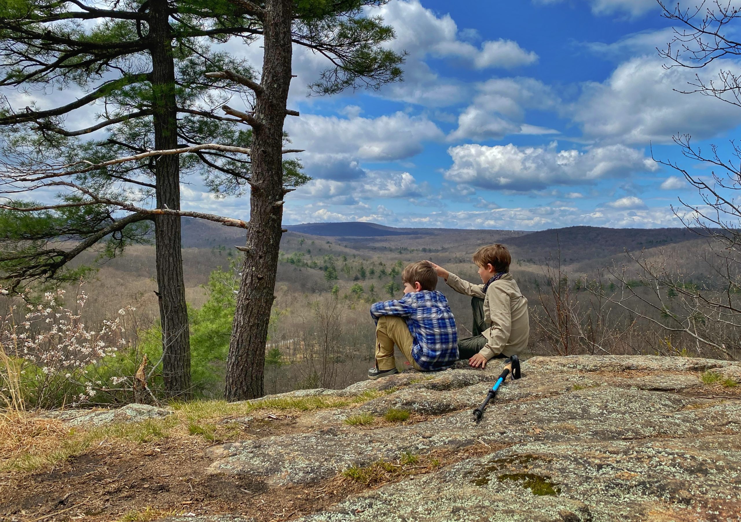
After a relatively level stretch, the trail climbs to the highest point on the ridge (1,047 feet). Turn right and walk a short distance to the edge of the ridge for a panoramic east-facing view over the Thruway and the Ramapo River Valley, with Harriman State Park beyond.

From the ridge, the trail descends gradually on switchbacks. Near the bottom, it briefly follows a stone wall, then turns right onto a woods road. At the base of the descent, it turns left onto a woods road between unusually wide stone walls. Now you’ve reached one of the area’s mysteries.

The trail proceeds for some distance between two truly massive eight-foot-wide stone walls – much wider and larger than the stone walls encountered elsewhere. Why were they built so wide? Did farmers just have lots and lots of stone to clear? Did these walls have something to do with mining activity? So far, no one has been able to offer more than conjecture.
Soon the trail turns right, passed through a gap in a massive stone wall, and continues on a footpath. To the right, you’ll notice a row of massive white oaks, over 100 years old (one of the trees is adjacent to the trail). After crossing a stone wall, the Indian Hill Loop Trail reaches a junction with the blue-blazed trail that begins on the right and heads north to connect, in 0.4 mile, with the white-blazed Appalachian Trail. Here, the Indian Hill Loop Trail turns left and begins to parallel a stone wall. It soon crossed two more stone walls, as well as a woods road lined on both sides with wide stone walls.
After passing through a wide gap in yet another stone wall, the trail turns left onto a grassy woods road. At a T-junction. it turns right onto another woods road, which it follows for about a quarter mile to a barrier gate. Here, you’ll see a triple blaze that marks the official end of the Indian Hill Loop Trail. Turn left and climb to the parking area, where you’ll notice a kiosk on the left and a triple blaze that marks the start of the Indian Hill Loop Trail.
Turn left and reenter the woods on a footpath. The trail proceeds through a hemlock grove, bears right, and climbs to the crest of a rise. After descending a little, it climbs through mountain laurel to reach an open granite ledge, with west-facing views over the hills of Sterling Forest.
A short distance beyond, you’ll reach a junction with the red-blazed Furnace Loop Trail (marked by a cairn). Turn right and descend steeply on this red-blazed trail, passing lichen-covered cliffs and interesting rock outcrops along the way. This is the steepest slope that you’ll encounter along the hike, and you should use extreme care, especially if the trail is wet or covered with snow or ice. At the base of the descent, you’ll reach a junction with the white-blazed Wildcat Mountain Trail.
Turn right, now retracing your steps, and follow the white blazes across the stream and along Hall Drive back to the parking area where the hike began.


