Overview
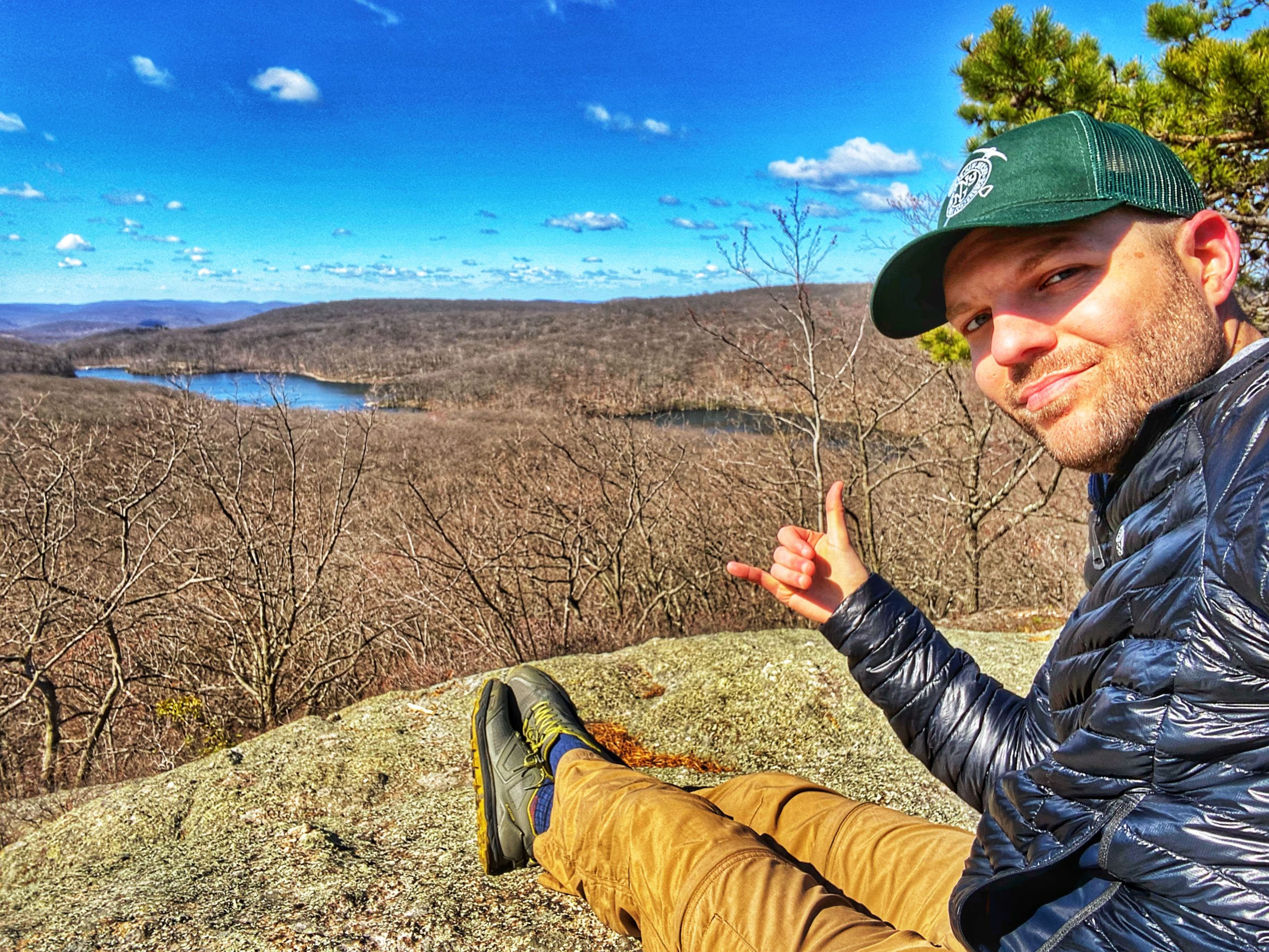
Traversing some of the less-traveled parts of Black Rock Forest, this loop packs a punch with spectacular views along multiple peaks.
Fun fact: Black Rock Forest isn’t public land and it’s not a park. It’s a private forest, but it is open to the public dawn to dusk.
Hike length: 9 miles
Elevation gain: +2,277 feet
Location: Black Rock Forest, Cornwall, NY
Black Rock Forest Parking
Park at the public parking lot located at 80 Reservoir Road, Cornwall, NY (41.418733,-74.010150).
About Black Rock Forest
Black Rock Forest is a living laboratory for field-based research and education, encompassing native terrestrial and aquatic ecosystems that are increasingly rare in the region. The 3,914-acre Forest features dramatic topography, more than 1,000 feet of relief, numerous lakes and streams, and high species and habitat diversity.
History (from the kiosk on Resrvoir Rd): Black Rock Forest was first established as a scientific research station by Dr. Ernest G. Stillman in 1927. Under his direction, long-term research plots were created that scientists continue to rely on today to investigate changes in our environment and forests.
In the 1960’s, Con Edison proposed building a pumped-storage power plant on neighboring Storm King Mountain. Several hundred acres of Black Rock Forest would have been submerged under the proposed plant’s storage reservoir.
A nationally publicized 17-year lawsuit ensued, considered to be the genesis of the modern environmental movement in the United States. The effort to block the plant was ultimately successful, sparking the creation of Scenic Hudson and the Natural Resources Defense Council (NRDC) and development of the National Environmental Policy Act (NEPA).
In 1989, national science policy advisor, financier, and philanthropist William T. Golden purchased the Forest and established the nonprofit Black Rock Forest Consortium with 15 partner schools and universities. Many of these institutions remain members to this day, and have been joined by several others.
In 2017, the organization began doing business simply as Black Rock Forest signaling the growth of programs and services for a broader constituency.
Impact: Since Black Rock Forest Consortium’s founding in 1989, the Forest has become one of the nation’s most active scientific field stations. More than 500 scientific papers have been produced by Consortium researchers, including 35 masters and Ph.D. dissertations. As a consequence of this research, we know a good deal more about the strengths of our region’s forests, including the effects on, and mechanisms of, carbon storage, water filtration, and ecosystem regulation by dominant species like oaks. We also know significantly more about the challenges faced in our region, including rising temperatures, more severe drought regimes, and other environmental conditions that increase native tree species’ vulnerability to pathogens or negatively affect their regeneration.
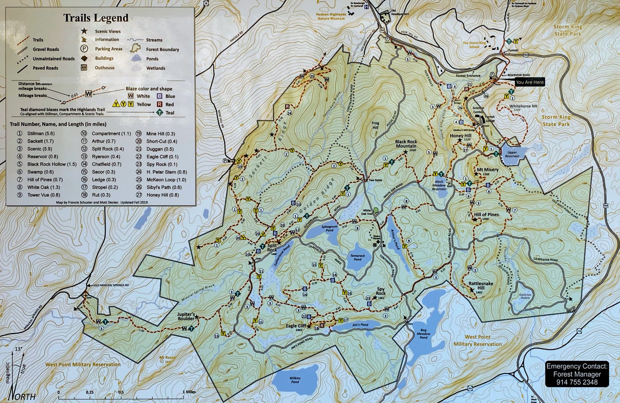
Black Rock Forest Maps
- Black Rock Forest trail map (Black Rock Forest, April 2020 map)
- West Hudson Trails Map #113 (NY-NJ Trail Conference paper map)
- Black Rock Forest also publishes its own trail map which is kept up to date with any trail changes and is available free of charge at the public kiosk in the parking lot on Reservoir Road. Stop by the kiosk and grab one before your hike.
Black Rock Forest Trail description
(from 50 Hikes in the Lower Hudson Valley)
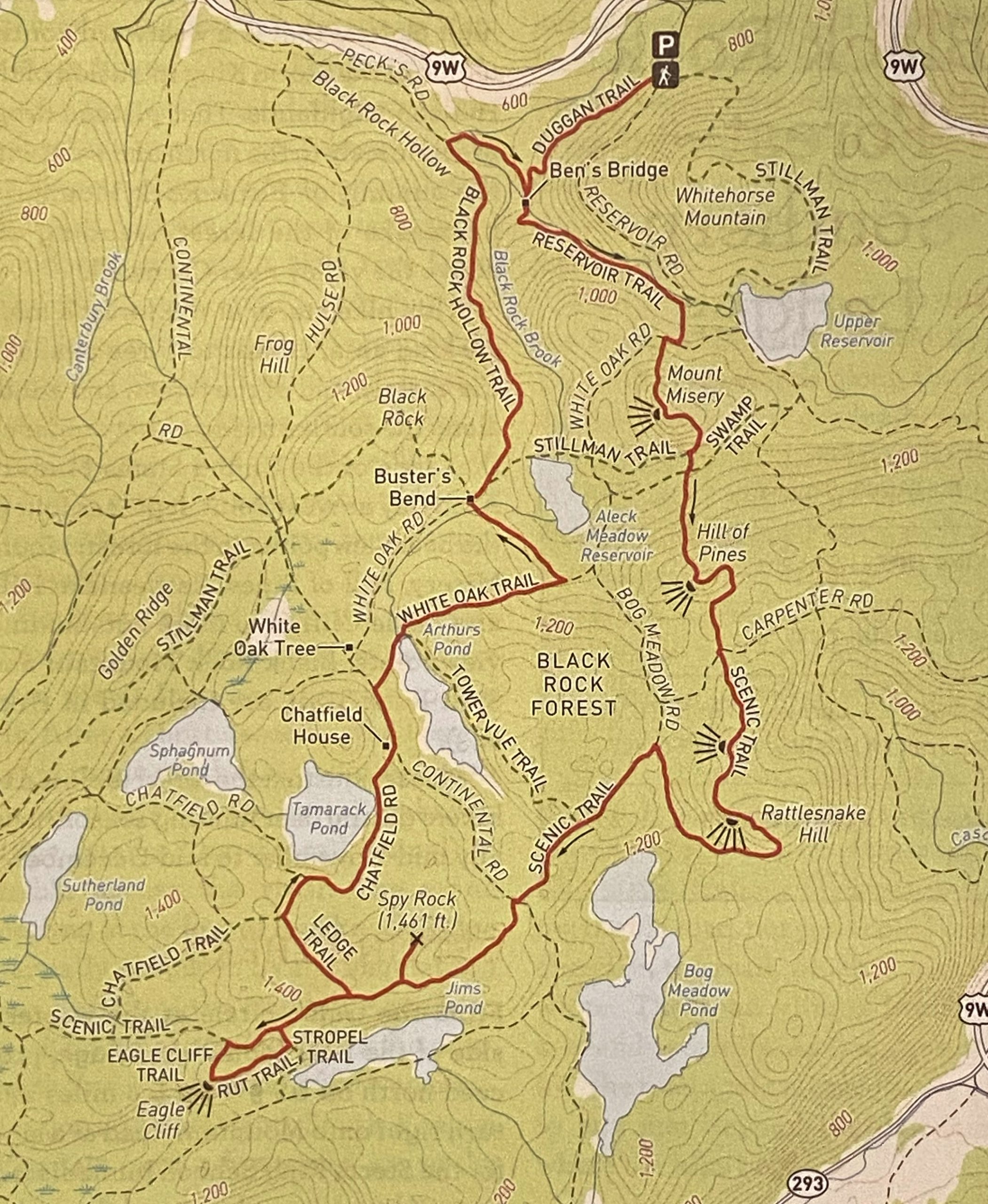
From the kiosk at the end of the parking area, bear right and proceed ahead on the red-blazed Duggan Trail, which heads downhill. In about half a mile, you’ll reach a gravel road. Here, the red trail ends at a junction with the blue-blazed Reservoir Trail. Continue ahead on the blue trail, which immediately crosses Ben’s Bridge (a wooden footbridge) and climbs along a picturesque stream, with cascades and waterfalls, following an old woods road.

In half a mile, you’ll notice a shiny pipeline crossing the stream. On the other side of the stream, you can see the Black Rock Forest’s Science Center. A short distance beyond, you’ll reach a junction where the white-blazed Honey Hill Trail departs to the right. Proceed ahead on the blue trail, which soon curves to the right and continues to parallel the stream. When the blue trail ends, bear right and continue ahead on the yellow-blazed Stillman Trail, which joins from the left.
Soon, the Stillman Trail reaches the dirt White Oak Road. Turn right onto the road, joining the teal-diamond-blazed Highlands Trail, but in 100 feet, turn left, leaving the road, and begin a steep climb of Mount Misery on a footpath. At the top (elevation 1,268 feet) you’ll reach a limited viewpoint to the west and northwest. Continue ahead for a short distance and you’ll come to a much better outlook, with Black Rock Mountain visible directly ahead and Aleck Meadow Reservoir below to the left. This is a good place to take a break (you’ve climbed nearly 700 vertical feet from Ben’s Bridge).
Continue ahead on the yellow/teal-diamond trail, which begins its descent of Mount Misery, first gradually and then more steeply. In a rugged, boulder-strewn area at the base of the descent, you’ll notice a triple-white blaze, which marks the start of the Scenic Trail. Turn left and follow the white-blazed Scenic Trail, which crosses the blue-blazed Swamp Trail at the end of the rocky area and begins a steady climb of the Hill of Pines, passing through attractive mountain laurel and hemlock.
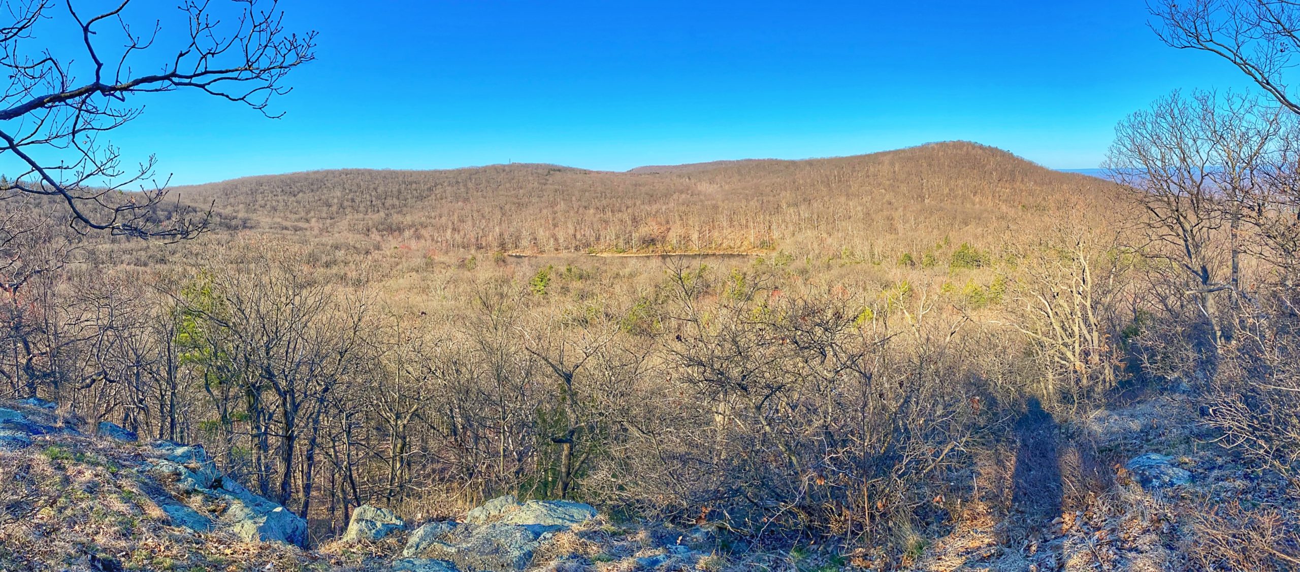
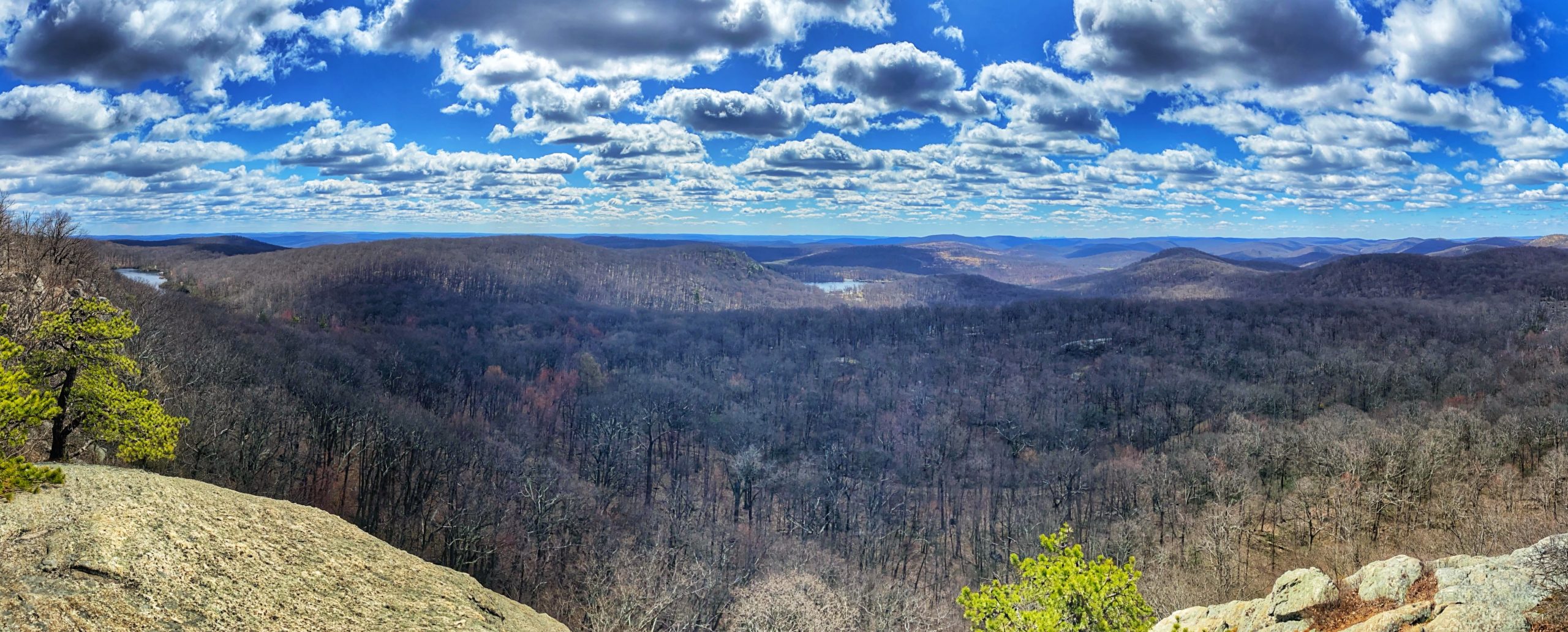
At the top of the climb, the trail emerges onto open rock, with a spectacular west-facing view. Black Rock Mountain may be seen on the right, and the Black Rock Forest fire tower is to its left. (Despite the name “Hill of Pines,” there are only two pines near the summit, which is mostly covered with oaks.)
The trail climbs a little to the true summit (elevation 1,400 feet), descend the hill, and soon crosses the dirt Carpenter Road diagonally to the right. You’ll now begin a gradual climb of Rattlesnake Hill. After reaching a high point and descending a little, you’ll arrive at a spot with a viewpoint about 100 feet to the right of the trail (from a rock ledge adjacent to a large pine tree). If you can’t find the path to this overlook, don’t be concerned, as you’ll soon reach two more viewpoints that are directly on the trail. You’ll now make a short but steep descent. After a relatively level stretch, you’ll reach a second overlook – this one marked by a cairn and a gnarled, nearly horizontal pine tree. The fire tower may be seen on the right, and Bog Meadow Pond lies directly below.
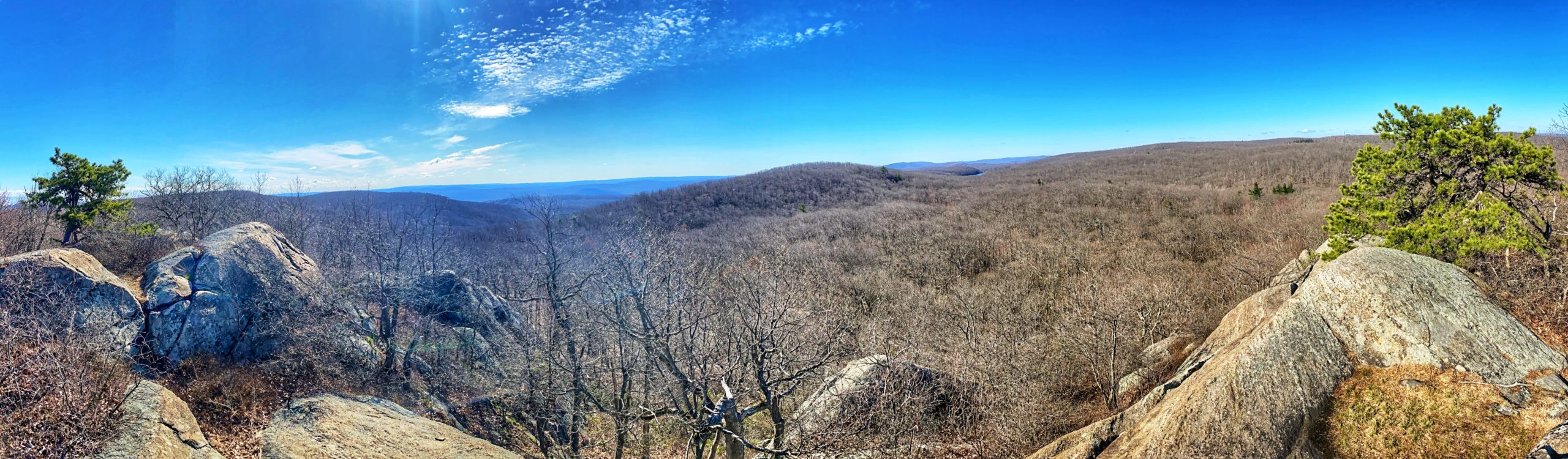
Continue ahead through a dense mountain laurel thicket to the third viewpoint n Rattlesnake hill, which offers a panoramic view from open rocks. Bog Meadow Pond is directly ahead, with the rolling hills of Orange County beyond.
Continue ahead on the white trail, which begins to descend – steeply, then more gradually. The trail briefly runs along the southern boundary of Black Rock Forest, with Bog Meadow Pond visible through the trees to the left.
After crossing the inlet stream of the pond, the trail climbs to the dirt Bog Meadow Road. Turn left onto the road, continuing to follow the white-blazed Scenic Trail. In a quarter mile, the yellow-blazed Tower Vue Trail begins on the right, but continue ahead on the road, following the white blazes. Soon you’ll reach a T-junction with Continental Road. Continue to follow the white-blazed Scenic Trail, which crosses the road diagonally to the right, reenters the woods, and begins to climb gradually.
When the trail levels off, watch carefully for a small cairn. Here, the blue-blazed Spy Rock Trail departs to the right. Turn right and follow this short trail, which leads about 750 feet to Spy Rock, marked by a single pitch pine. This is the highest point in Black Rock Forest (1,461 feet). During the Revolutionary War, this rock outcrop was used as a lookout by Continental soldiers to monitor the area, but today, vegetation obscures most of the views, and only a limited north-facing view remains.

Retrace your steps to the white-blazed Scenic Trail and turn right. Soon you’ll pass the yellow-blazed Ledge Trail, which begins on the right and then the Stropel Trail (also yellow-blazed), which goes off to the left. Proceed ahead on the white-blazed Scenic Trail, but a short distance beyond, turn left onto the blue-blazed Eagle Cliff Trail, which soon reaches Eagle Cliff – a huge rock outcrop with glacial striations. You’ll have to use both your hands and your feet to climb to the top of the outcrop, but when you reach it, you’ll be rewarded with a panoramic south-facing view. Wilkins Pond (on the grounds of the United State Military Academy at West Point) is straight ahead, and Jim’s Pond is on the left. On a clear day, you may be able to see the New York City skyline in the distance. This is a good place to take a break.


When you’re ready to continue, bear right onto the orange-blazed Rut Trail, which runs near the edge of the escarpment, with views through the trees on the right. Be alert for a sharp left turn, where the trail turns slightly away from the cliff edge and goes down through a narrow passage between boulders. Soon you’ll reach a trail junction, where the Rut Trail ends. Turn left onto the yellow-blazed Stropel Trail, which leads a very short distance to the white-blazed Scenic Trail. Turn right and rejoin the Scenic Trail.
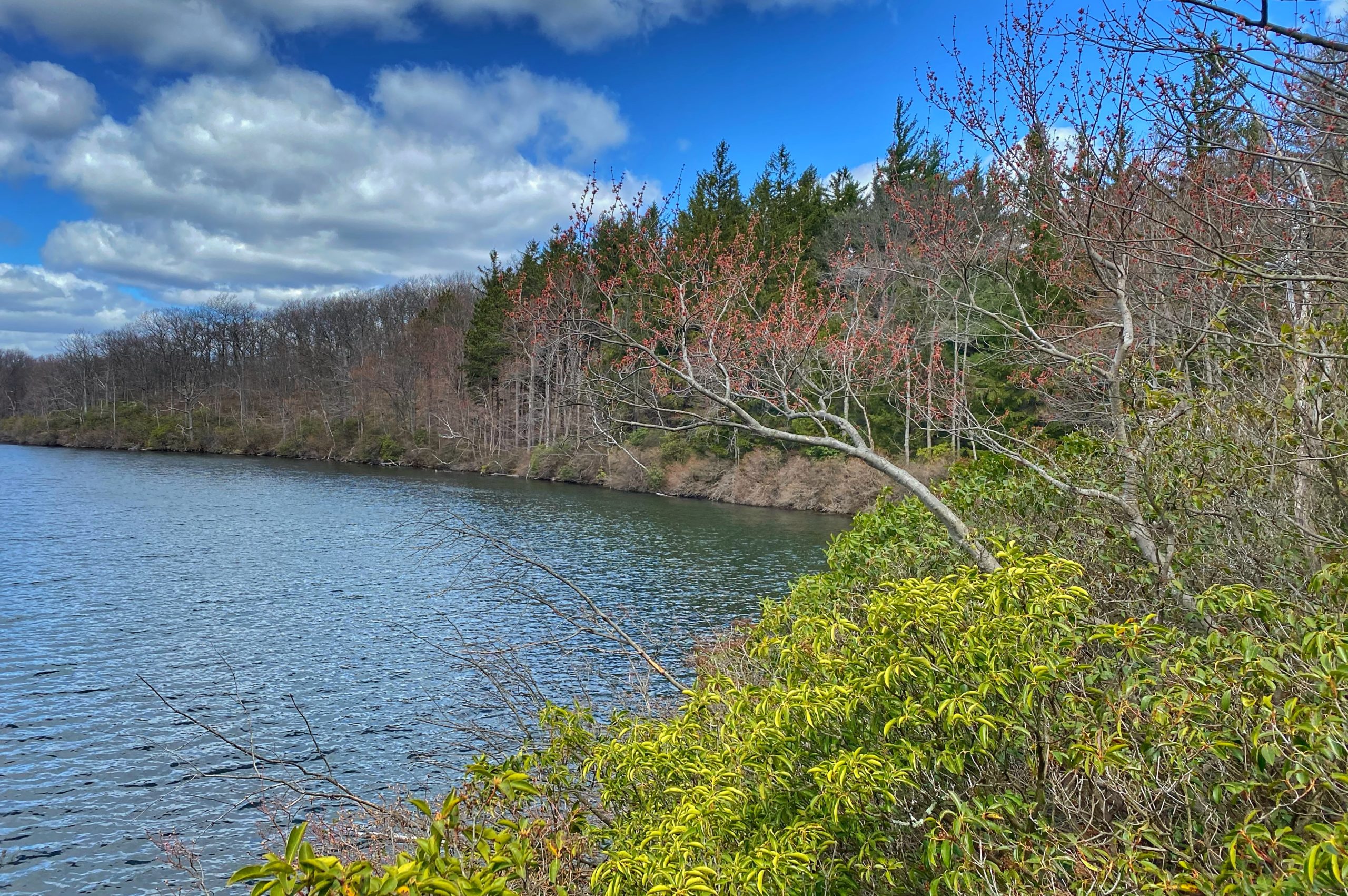
In another 0.2 mile, the yellow-blazed Ledge Trail begins on the left. Turn left onto this trail, which climbs over a rise, descends gently, then climbs a little more to end at a T-junction with the blue-blazed Chatfield Trail. Turn right onto the Chatfield Trail and descend to Chatfield Road, then turn right onto the road and follow it past Tamarack Pond, visible on the left through the trees.
At the end of the pond, as the road curves to the right, a path straight ahead leads to the Moretti Outpost (a covered open pavilion). A short distance ahead, you’ll reach the intersection of Chatfield and Continental Roads.
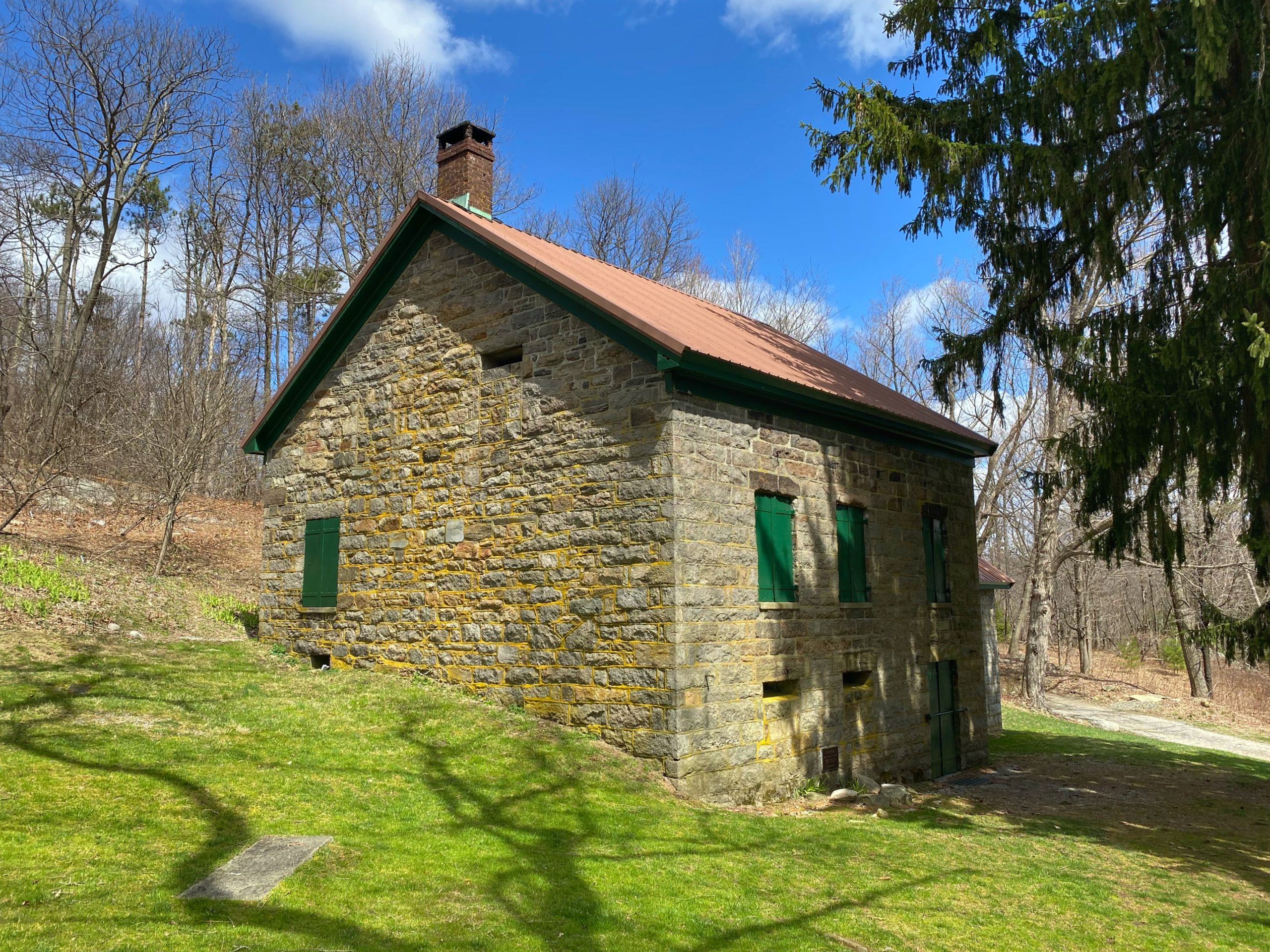
At this intersection, you’ll notice an old stone building with a distinctive bulging chimney, indicative of a beehive oven inside. This is the Chatfield House, built in 1834 – the oldest building in Black Rock Forest. The house was gutted by fire in 1913 and restored in 1932 by Dr. Stillman. The lands nearby were once pastures and orchards, and Tamarack Pond, originally called Orchard Pond, was used as a cranberry bog. Today, the Chatfield House is used for educational programs.
Turn left onto Continental Road, but follow it for only 500 feet and turn right onto the white-blazed White Oak Trail (here on a wide gravel road). After passing the northern end of Arthurs Pond and crossing the outlet stream of the pond just below the dam, you’ll reach a junction with the yellow-blazed Tower Vue Trail, which begins on the right. Continue ahead on the white-blazed White Oak Trail, which descends to White Oak Road near the Aleck Meadow Reservoir. Turn left onto the road and head toward Black Rock Mountain (visible in the distance). (NOTE: If the water is high and you are unable to cross the outlet stream of Arthurs Pond below the dam, retrace your steps to Continental Road and turn right. Continue to the next intersection, marked by a huge oak tree, and turn right onto White Oak Road. In half a mile, you’ll reach Buster’s End, marked by a sign. Turn left here onto a short unmarked trail and continue with the route of the hike as described in the next paragraph.)
Just beyond a stream crossing (the stream is the outlet of Arthurs Pond), the road curves to the left. This spot is marked by a sign identifying it as BUSTER’S BEND. Here, on the right, you’ll notice a short unmarked trail which leads up to the yellow-blazed Stillman Trail (also the route of the teal-diamond-blazed Highlands Trail). Turn right onto this short connector trail, then turn right onto the Stillman/Highlands Trail, which follows a woods road. A short distance beyond, the yellow and teal-diamond blazes turn right, but you should continue ahead, now following the white-blazed Black Rock Hollow Trail along a section of the road which has narrowed to a footpath. The trail descends along the road, with portions rerouted to bypass very eroded sections of the road.
At the base of the descent, the white-blazed trail ends at a filtration plant. Turn right onto the blue-blazed Reservoir Trail and following it around the plant and along the brook to a junction with the red-blazed Duggan Trail just before Ben’s Bridge. Turn sharply left onto the red-blazed trail and follow it up uphill to the parking area where the hike began.


